Geoscience Reference
In-Depth Information
14.2.1.4
Authoritative Data
Authoritative data are collected, produced, and managed by professional cartogra-
phers, geographers, and/or government agencies. Information which comes from
these official, authoritative persons or agencies carries a certain level of trust which
affords them credibility (Flanagin and Metzger
2008
; Goodchild and Glennon
2010
). Examples of authoritative data may include remote sensing imagery collected
and calibrated by NASA or stream flow information collected from USGS river
gauges. These are our traditional sources of data and information during disasters
and emergencies.
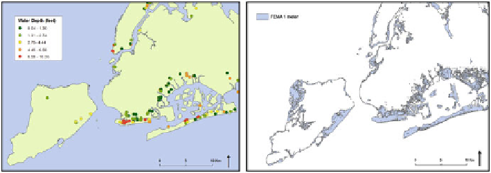
Federal Emergency Management Agency (FEMA)
The FEMA Modeling Task Force (MOTF) consists of experts in hazard assessment
and the modeling of hazard losses. Following Hurricane Sandy, FEMA MOTF used
field-verified high water marks and storm surge sensor data to create storm surge
maps for the US East Coast. For this work, a FEMA MOTF storm surge shapefile for
New York City was downloaded from FEMA's GeoPlatform website. The surge map
was the finalized version (dated February 14, 2013) with a 1 m horizontal resolution
and a New York State Plane coordinate system (Fig.
14.4
(right)).
Water depth data were also collected at inundated New York City public schools
by FEMA MOTF. The water depth at schools was ascertained from water marks
taken from on-site structures (Fig.
14.4
(left)). A GIS layer was created from
georeferenced point locations of the schools with measured water depths.
United States Geological Survey (USGS)
Water height collected by the USGS storm-tide monitoring provides an additional
source of authoritative ground data. These official measurements were taken at
Fig. 14.4
FEMA water depth measured at public schools (
left
) and official flood inundation map
(
right
)
Search WWH ::

Custom Search