Geoscience Reference
In-Depth Information
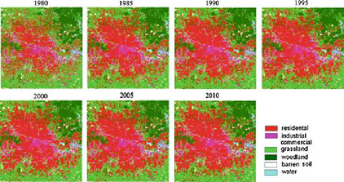
Fig. 12.5
The simulated landscape pattern of Houston without the socioeconomic factors
be observed in the southeastern and northeastern city with a large amount of new
residential and industrial/commercial area being built in the last 30 years. Different
from other large cities in the United States, Houston did not adopt city zoning laws
in its urban planning. Lacking city zoning has led to an abundance of urban sprawl in
Houston, resulting in a relatively large metropolitan area and low population density.
Land developers inspired the spread of Houston when they built suburbs such as
Pasadena (1892), Houston Heights (1892), Deer Park (1892), Bellaire (1911), West
University Place (1919), and River Oaks (1922-24).
Although the simulated results from two models have the similar sprawl pattern,
the model with the parameterized socioeconomic variables had a better correspon-
dence with the “abrupt” expansion in residential and industrial/commercial area.
From Fig.
12.6
, we could find that the “abrupt” expansion were simulated well in
the model with the socioeconomic data as the larger predicted area in these human-
related landscapes in the year 2010. This “abrupt” expansion was caused by the
rapid economic development, population growth, and road construction in Houston.
The simulated pattern by the model without socioeconomic factors was much
tardier, especially in simulating the rapid growth in suburban area. The differences
between these two models indicate that the CA spatial model could simulate the
urban evolution behaviors with incorporating enough driving factors.
In order to display the error in the predicted map, we compared our predicted
results with the empirical maps. The differential map was shown in Fig.
12.7
.
White pixels in the figure represented the area predicted correctly, while dark
pixels represented the incorrect prediction. Generally, the residential areas were best
predicted and most of the errors were found in the suburban area, which were mostly
grassland and barren/soil landscapes. The woodland was predicted better than other
natural landscapes, which might be caused by the large forest reserved area in
northeastern Houston in the Sheldon Lake State Park and Dwight D. Eisenhower
Park.
Search WWH ::

Custom Search