Geoscience Reference
In-Depth Information
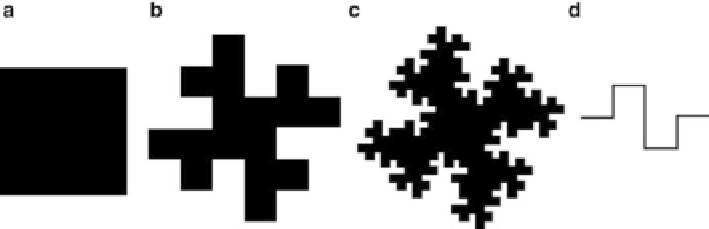
Fig. 2.5
The first three steps for generating a teragon. Each side of the initially given
square
(
a
) is replaced by the polygon (
d
) what generates figure (
b
). By reiterating this mapping, figure
(
c
) is obtained (Mandelbrot
1982
)
There are also fractals with compact surface areas of
D
D
2 but which have just
a fractal boundary, like the teragon of Fig.
2.5
. Here, in the course of iteration, the
surface area remains the same but is distributed differently at each step so that the
border becomes increasingly filigree, its length tending to infinity, and its fractal
dimension amounts to
D
D
1.5.
We remind that fractal dimension should not be confused with density (Fig.
2.2
).
A suburban area consisting of big lots where individual houses are uniformly
distributed in space has globally a fractal dimension of
D
D
2, but low density.
However, a neighborhood made of uniformly distributed row houses along the
streets is certainly denser, but, since build-up area is uniformly distributed, too, the
fractal dimension would also be
D
D
2.
When referring to real-world situation, we usually stop the iteration at a certain
step
n
. Mandelbrot called such objects
prefractals
. For instance, if the size of the
initial figure corresponds to the area occupied by an agglomeration of a metropolitan
area, we stop the iteration as soon as the size of the elements is comparable to the
size of a building. Hence, we have a certain range for which we observe the scaling
properties of fractals for which the distribution of the elements can be described by
the fractal dimension. We now focus on the question of how to explore the fractal
properties of empirical structures.
2.4
Measuring Fractality
2.4.1
General Methodology
Obviously, urban patterns are not generated by an iterative mapping procedure but
result from complex interactions between different types of decision makers, such
as politicians, planners, landowners, land developers, and so on. Hence, measuring
methods must be used by which to verify to what extent the spatial organization
Search WWH ::

Custom Search