Geoscience Reference
In-Depth Information
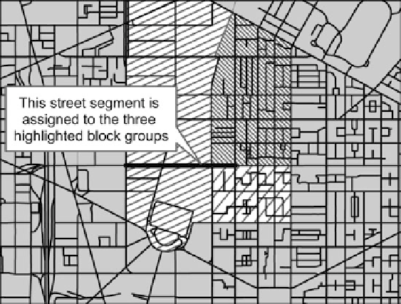
Fig. 7.1
Street segment assigned to multiple block groups
are then totaled for each block group and a density is calculated from these totaled
values. Finally, these values are then rescaled from 0 to 1 utilizing the equation:
.V
i
V
min
/
.V
max
V
min
/
D
V
r
(7.1)
where
V
i
equals the value to be rescaled,
V
min
equals the lowest density calculated,
and the
V
max
equals the highest density calculated. This results in all values being
scaled from 0 to 1, with values closer to 0 having a lower density than values closer
to 1. This maintains the natural distribution of the dataset.
For the second parameter, block length, each street segment (excluding alley-
ways, driveways, and ramps) is assigned to a block group or number of block groups.
In some cases, segments are assigned to as many as three different block groups. In
Fig.
7.1
a street segment is shown that is assigned to three separate block groups,
due to a number of “intersections” actually being over-/underpasses, meaning that
this segment runs uninterrupted through multiple block groups. Street segments
are assigned to block groups that they are either fully contained by or intersect
(including boundary intersection). However, segments that only share one vertex
with the block group are not included.
The total number of street segments and their total lengths for each block group
are then calculated and a mean street segment length for each block group is
determined. Finally, the mean street segment length for each block group is rescaled
from 0 to 1 utilizing the same format as Eq.
7.1
,where
V
i
equals the value to be
rescaled,
V
min
equals the lowest mean street segment length, and the
V
max
equals
Search WWH ::

Custom Search