Geography Reference
In-Depth Information
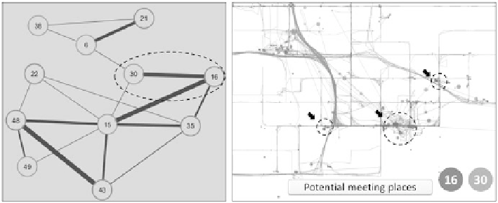
Fig. 20.16
An example of a social network based on space-time proximity that implies opportu-
nities for interactions
smart phones), geotagged tweets and photographs, and numerous other means,
we can attach location information and record movements for animals, people,
goods, and services. While time geography offers a rich conceptual framework
to examine spatial behavior and interactions among individuals, research on tra-
jectory analysis, trajectory mining, and more generally, mobile object modeling
has developed many statistical or computational methods to identify clusters or
detect outliners in movement data. Many of these studies considered only geometric
or semantic properties of trajectories. Instead, this chapter advocates for a space-
time analytics approach to examine reoccurring movements of individuals and from
the reoccurring movements to identify patterns of life and their opportunities for
interactions based on proximity in space and time.
The chapter defines the terms: paths, tracks, trajectories, stops and moves, while
the meanings of these terms may vary in the literature. Paths are actual routes
taken by individuals, tracks are composed of observed locations, trajectories are
interpolated paths between observed locations, and stops and moves are observed
locations with durations of non-movement in transit. Space-time analytics of tracks
emphasize elements of tracks and how the elements may be structured for analysis.
Stops, moves, and track segments are considered in this chapter as elements of
tracks, and Geohash boxes and chronological time are used to structure space and
time for georeferencing and sequencing stops and moves to form tracks for analysis.
Spatial clusters and time spent at locations are criteria used to identify stops along
tracks. Analysis of stops reveals the place where an individual frequently visits and
visiting patterns. Observed locations are resampled to form tracks with stops and
moves in Geohash codes at common time intervals.
Comparison of corresponding Geohash strings at time intervals reveals how
an individual might have taken a different route or changed travel behavior (left
early/late or at a higher speed). In this chapter, we show three ways to compare
tracks: (1) line graphs that show variations across multiple days; (2) space-time-
track images to highlight high and low differences in tracks throughout a day
Search WWH ::

Custom Search