Geography Reference
In-Depth Information
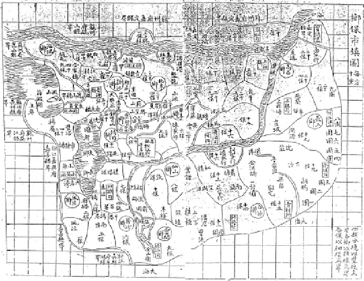
Fig. 11.3
The map of sub-county divisions and market towns of the
Songjiang fuji
Nevertheless, there was more than one accurate town location alongside the
other topological points and township boundary information in each of the
bao
units. As such, we abandoned the Thessian polygons and opted for recreating these
boundaries according to our own method, which relied heavily on the information
provided by the local gazetteers.
The abstract maps of the “Xiangbao shizhen tu
(map of sub-
county divisions and market towns)” found in category (2) of maps and diagrams
of the
Songjiang fuji
published in the Jiajing reign (1792-1820) in the mid-Qing
period) were our main references for determining the basic shape of the
bao
polygons (Fig.
11.3
). However, because this map was not drawn according to
modern cartography standards, further evidence was required to modify the drafted
boundaries of the
bao
. Three more steps were therefore necessary to produce
polygons that met our expectations.
First, we believe that when the
bao
was created, there were solid reasons for
drawing their boundaries, and the best grounds for division were undoubtedly
natural landmarks such as rivers and hills. Therefore, roughly following the shapes
of the
bao
as shown in the local gazetteer maps, we moved their borders to nearby
topological features shown on the base maps. Second, we modified the boundaries
by consulting the waters displayed in the high resolution
Shanghai lishi dituji
maps
and contemporary satellite photos of the Shanghai region.
鄉保市鎮圖
Search WWH ::

Custom Search