Geology Reference
In-Depth Information
Earth's crust in the
Basin and Range Province
(Figure 23.4)—
an area centered on Nevada but extending into adja-
cent states and northern Mexico—has been stretched
and thinned, yielding north-south-oriented mountain
ranges with intervening valleys or basins. The ranges are
bounded on one or both sides by steeply dipping normal
faults that probably curve and dip less steeply with depth
(
The vast, elevated
Colorado Plateau
in Colorado, Utah,
Arizona, and New Mexico has volcanic mountains rising
above it, brilliantly colored rocks, and deep canyons. In
Chapters 20 and 22, we noted that during the Permian and
Triassic, the Colorado Plateau region was the site of extensive
red bed deposition; many of these rocks are now exposed in
the uplifts and canyons (
Figure 23.8).
Cretaceous-age marine sedimentary rocks indicate that
the Colorado Plateau was below sea level, but during the
Paleogene Period, Laramide deformation yielded broad anti-
clines and arches and basins, and a number of large normal
faults. Neogene uplift elevated the region from near sea level
to the 1200- to 1800-m elevations seen today, and as uplift
proceeded, streams and rivers began eroding deep canyons.
Geologists disagree on the details of just how the deep
canyons so typical of the region developed—such as the
Grand Canyon (see Chapter 20 Geo-inSight on pages 534 and
535). Some think that the streams were
antecedent
, meaning
that they existed before the present topography developed, in
which case they simply eroded downward as uplift proceeded.
Others think that the streams were
superposed,
implying
that younger strata covered the area on which streams
were established. During uplift, the streams stripped away
these younger rocks and eroded down into the underlying
strata. In either case, the landscape continues to evolve as
◗
Figure 23.7a).
Before faulting began, the region was deformed during
the Nevadan, Sevier, and Laramide orogenies. Then dur-
ing the Paleogene, the entire area was highlands undergoing
extensive erosion, but Early Miocene eruptions of rhyolitic
lava fl ows and pyroclastic materials covered large areas. By
the Late Miocene, large-scale faulting had begun, forming
the basins and ranges. Sediment derived from the ranges
was transported into the adjacent basins and accumulated as
alluvial fan and playa lake deposits.
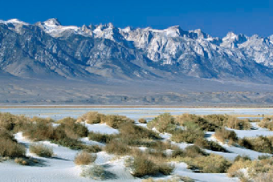
At its western margin, the Basin and Range Province is
bounded by normal faults along the east face of the Sierra
Nevada (Figure 23.7b). Pliocene and Pleistocene uplift
tilted the Sierra Nevada toward the west, and its crest now
stands 3000 m above the basins to the east. Before this uplift
took place, the Basin and Range Province had a subtropi-
cal climate, but the rising mountains created a rain shadow,
making the climate increasingly arid.
◗
◗
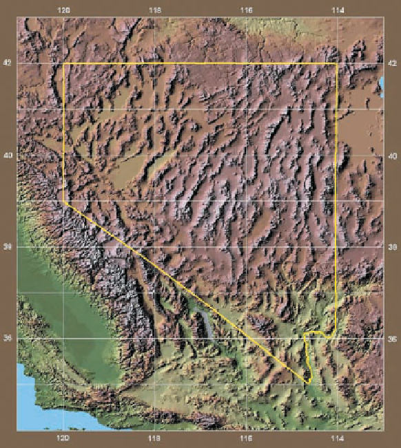
Figure 23.7
The Basin and Range Province
a
The Basin and Range is mostly in Nevada, but it extends
to adjacent states and northern Mexico. The ranges and
the intervening basins trend north-south. Each range is
bounded on one or both sides by normal faults.
b
The Sierra Nevada at the western margin of the Basin
and Range has risen along normal faults so that it is more
than 3000 m above the valley to the east.


Search WWH ::

Custom Search