Geology Reference
In-Depth Information
multicolored sandstones, mud-
stones, shales, and occasional lenses
of conglomerates that constitute the
world-famous
Morrison Formation
(
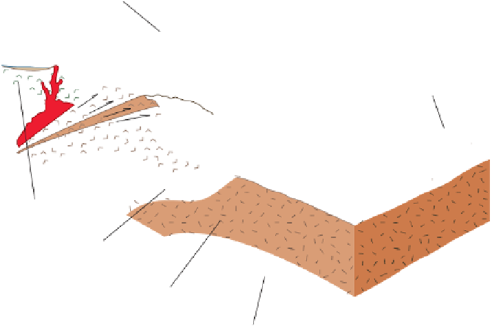
Volcanic
island arc
Sea level
California
Nevada
West
Sonoma
Mountains
Figure 22.17a).
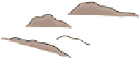
The Morrison Formation con-
tains the world's richest assem-
blage of Jurassic dinosaur remains
(Figure 22.17b). Although most of
the dinosaur skeletons are broken up,
as many as 50 individuals have been
found together in a small area. Such
a concentration indicates that the
skeletons were brought together dur-
ing times of fl ooding and deposited
on sandbars in stream channels. Soils
in the Morrison Formation indicate
that the climate was seasonably dry.
Shortly before the end of the
Early Cretaceous, Arctic waters
spread southward over the craton,
forming a large inland sea in the
Cordilleran region. Mid-Cretaceous
transgressions also occurred on
other continents, and all were part
of the global mid-Cretaceous rise
in sea level that resulted from ac-
celerated seafl oor spreading as Pangaea continued to frag-
ment. These Middle Cretaceous transgressions are marked
by widespread black shale deposition within the oceanic
areas, the shallow sea shelf areas, and the continental re-
gions that were inundated by the transgressions.
By the beginning of the Late Cretaceous, this incursion
joined the northward-transgressing waters from the Gulf
area to create an enormous
Cretaceous Interior Seaway
that
occupied the area east of the Sevier orogenic belt. Extending
from the Gulf of Mexico to the Arctic Ocean, and more than
1500 km wide at its maximum extent, this seaway effectively
divided North America into two large landmasses until just
before the end of the Late Cretaceous (Figure 22.6).
Cretaceous deposits less than 100 m thick indicate that
the eastern margin of the Cretaceous Interior Seaway sub-
sided slowly and received little sediment from the emergent,
low-relief craton to the east. The western shoreline, however,
shifted back and forth, primarily in response to fl uctuations
in the supply of sediment from the Cordilleran Sevier oro-
genic belt to the west. The facies relationships show lateral
changes from conglomerate and coarse sandstone adjacent to
the mountain belt through fi ner sandstones, siltstones, shales,
and even limestones and chalks in the east. During times of
particularly active mountain building, these coarse clastic
wedges of gravel and sand prograded even farther east.
As the Mesozoic Era ended, the Cretaceous Interior Sea-
way withdrew from the craton. During this regression, ma-
rine waters retreated to the north and south, and marginal
marine and continental deposition formed widespread coal-
bearing deposits on the coastal plain.
◗
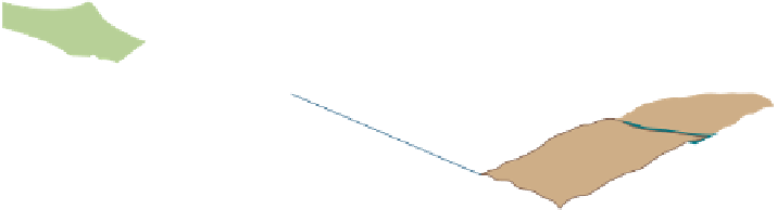
Craton
East
Oceanic crust
Antler orogenic belt
and associated thrust faults
Continental crust
Upper mantle
◗
Figure 22.8
Sonoma Orogeny Tectonic activity that culminated in the Permian-Triassic
Sonoma orogeny in western North America. The Sonoma orogeny was the result of a collision
between the southwestern margin of North America and an island arc system.
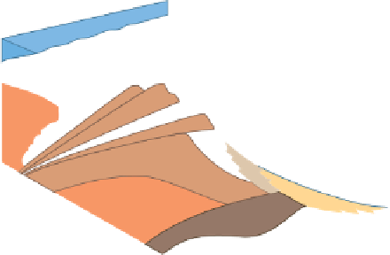
These rocks represent a variety of continental deposi-
tional environments. The Upper Triassic
Chinle Formation,
for
example, is widely exposed throughout the Colorado Plateau
region and is probably most famous for its petrifi ed wood spec-
tacularly exposed in Petrifi ed Forest National Park, Arizona
(
Figure 22.15). This formation, as well as other Triassic
formations in the Southwest, also contains the fossilized re-
mains and tracks of various amphibians and reptiles.
Early Jurassic-age deposits in a large part of the west-
ern region consist mostly of clean, cross-bedded sand-
stones indicative of wind-blown deposits. The thickest
and most prominent of these is the
Navajo Sandstone,
a
widespread cross-bedded sandstone that accumulated in a
coastal dune environment along the southwestern margin
of the craton. The sandstone's most distinguishing feature
is its large-scale cross-beds, some of which are more than
25 m high (
◗
Figure 22.16).
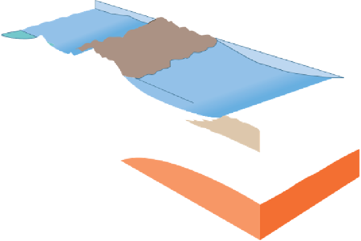
Marine conditions returned to the region during the Mid-
dle Jurassic when a wide seaway called the
Sundance Sea
twice
fl ooded the interior of western North America (Figure 22.5).
The resulting deposits, the
Sundance Formation,
were produced
from erosion of tectonic highlands to the west that paralleled
the shoreline. These highlands resulted from intrusive igneous
activity and associated volcanism that began during the Triassic.
During the Late Jurassic, a mountain chain formed
in Nevada, Utah, and Idaho as a result of the deforma-
tion produced by the Nevadan orogeny. As the mountain
chain grew and shed sediments eastward, the Sundance Sea
began retreating northward. A large part of the area for-
merly occupied by the Sundance Sea was then covered by
◗


Search WWH ::

Custom Search