Geology Reference
In-Depth Information
Hudson River in the New York-
New Jersey area (Figure 22.7d).
As the Atlantic Ocean grew,
rifting ceased along the east-
ern margin of North America,
and this once-active convergent
plate margin became a passive,
trailing continental margin. The
fault-block mountains produced
by this rifting continued to erode
during the Jurassic and Early
Cretaceous until all that was left
was an area of low relief.
The sediments produced
by this erosion contributed to
the growing eastern continental
shelf. During the Cretaceous Pe-
riod, the Appalachian region was
reelevated and once again shed
sediments onto the continental
shelf, forming a gently dipping,
seaward-thickening wedge of
rocks up to 3000 m thick. These
rocks are currently exposed in a
belt extending from Long Island,
New York, to Georgia.
The Gulf Coastal region was
above sea level until the Late
Triassic (Figure 22.4). As North
America separated from South
America during the Late Trias-
sic, the Gulf of Mexico began to
form (Figure 22.5). With oceanic
waters flowing into this newly
formed, shallow, restricted ba-
sin, conditions were ideal for
evaporite formation. More than
1000 m of evaporites were pre-
cipitated at this time, and most
geologists think that these Jurassic evaporites are the source
for the Cenozoic salt domes found today in the Gulf of Mex-
ico and southern Louisiana.
By the Late Jurassic, circulation in the Gulf of Mexico
was less restricted, and evaporite deposition ended. Nor-
mal marine conditions returned to the area with alternating
transgressing and regressing seas. The resulting sediments
were covered and buried by thousands of meters of Creta-
ceous and Cenozoic sediments.
During the Cretaceous, the Gulf Coastal region,
like the rest of the continental margin, was flooded by
northward-transgressing seas (Figure 22.6). As a result, near-
shore sandstones are overlain by fi ner sediments character-
istic of deeper waters. Following an extensive regression at
the end of the Early Cretaceous, a major transgression began
during which a wide seaway extended from the Arctic Ocean
◗
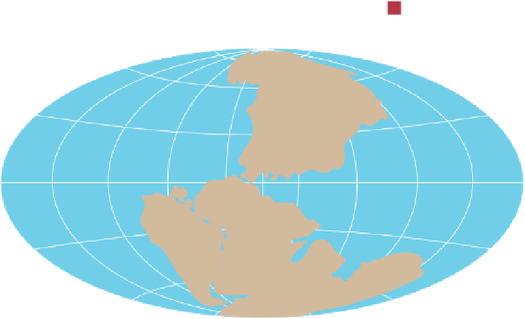
Figure 22.3
Mesozoic Oceanic Circulation Patterns Oceanic circulation evolved from
a
a simple
pattern in a single ocean (Panthalassa) with a single continent (Pangaea) to
b
a more complex
pattern in the newly formed oceans of the Cretaceous Period.
60
°
Eurasia
30
°
North
America
0
°
Equator
South
America
Africa
30
°
India
Australia
60
°
Antarctica
Tr
iassic Period
a
60
°
North
America
Eurasia
30
°
0
°
Equator
Africa
South
America
India
30
°
Australia
60
°
Antarctica
Cretaceous Period
b
magma beneath Pangaea in a zone stretching from present-
day Nova Scotia to North Carolina (
Figure 22.7). Erosion
of the fault-block mountains fi lled the adjacent basins with
great quantities (up to 6000 m) of poorly sorted red nonma-
rine detrital sediments known as the
Newark Group.
Reptiles roamed along the margins of the lakes and
streams that formed in these basins, leaving their footprints
and trackways in the soft sediments. Although the Newark
rocks contain numerous dinosaur footprints, they are almost
completely devoid of dinosaur bones! The Newark Group is
mostly Late Triassic in age, but in some areas deposition did
not begin until the Early Jurassic.
Concurrent with sedimentation in the fault-block ba-
sins were extensive lava fl ows that blanketed the basin fl oors,
as well as intrusions of numerous dikes and sills. The most
famous intrusion is the prominent Palisades sill along the
◗


Search WWH ::

Custom Search