Geology Reference
In-Depth Information
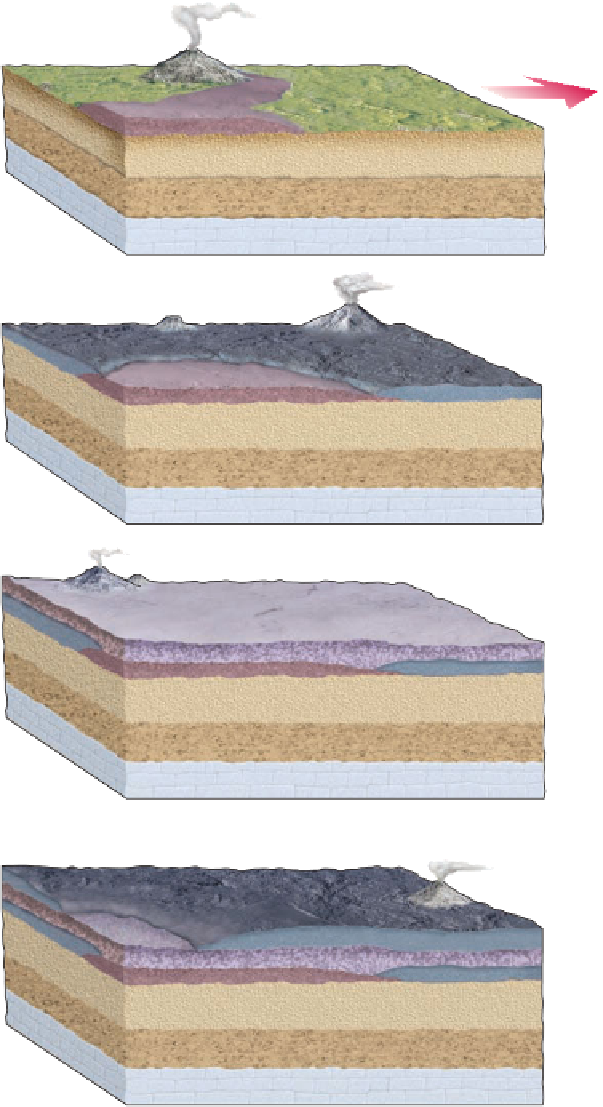
such a reversal, the magnetic field
weakens until it temporarily dis-
appears. When the magnetic field
returns, the magnetic poles have re-
versed their position. The existence
of such
magnetic reversals
was
discovered by dating and determin-
ing the orientation of the remanent
magnetism in lava flows on land
(
South magnetic
pole (normal
position)
North magnetic
pole (normal
position)
Figure 2.10). Although the cause
of magnetic reversals is still uncer-
tain, their occurrence in the geo-
logic record is well documented.
A renewed interest in oceano-
graphic research led to extensive
mapping of the ocean basins during
the 1960s. Such mapping revealed
an oceanic ridge system more than
65,000 km long, constituting the
most extensive mountain range in
the world. Perhaps the best-known
part of the ridge system is the
Mid-Atlantic Ridge, which divides
the Atlantic Ocean basin into two
nearly equal parts (
◗
a
North magnetic
pole (reversed)
South magnetic
pole (reversed)
b
South magnetic
pole (normal)
North magnetic
pole (normal)
Figure 2.11).
As a result of oceanographic re-
search conducted during the 1950s,
Harry Hess of Princeton University
proposed, in a 1962 landmark paper,
the theory of
seafloor spreading
to account for continental move-
ment. He suggested that continents
do not move through oceanic crust
as do ships plowing through sea ice,
but rather that the continents and
oceanic crust move together as a
single unit. Thus, the theory of sea-
floor spreading answered a major
objection of the opponents of con-
tinental drift—namely, how could
continents move through oceanic
crust? In fact, the continents moved
with the oceanic crust as part of a
lithospheric system.
Hess postulated that the sea-
floor separates at oceanic ridges,
where new crust is formed by up-
welling magma. As the magma
cools, the newly formed oceanic
crust moves laterally away from the
ridge.
As a mechanism to drive this
system, Hess revived the idea (first
proposed in the late 1920s by the
British geologist Arthur Holmes) of a heat transfer system—or
thermal convection cells
—within the mantle as a mecha-
nism to move the plates. According to Hess, hot magma rises
from the mantle, intrudes along fractures defining oceanic
◗
c
South magnetic
pole (reversed)
North magnetic
pole (reversed)
d
◗
Figure 2.10
Magnetic Reversals During the time period shown (a-d), volcanic eruptions
produced a succession of overlapping lava fl ows. At the time of these volcanic eruptions, Earth's
magnetic fi eld completely reversed—that is, the magnetic north pole moved to the geographic
south pole, and the magnetic south pole moved to the geographic north pole. Thus, the end
of the needle of a magnetic compass that today would point to the North Pole would point to
the South Pole if the magnetic fi eld should again reverse. We know that Earth's magnetic fi eld
has reversed numerous time in the past because when lava fl ows cool below the Curie point,
magnetic minerals within the fl ow orient themselves parallel to the magnetic fi eld at the time.
They thus record whether the magnetic fi eld was normal or reversed at that time. The white
arrows in this diagram show the direction of the north magnetic pole for each individual lava fl ow,
thus confi rming that Earth's magnetic fi eld has reversed in the past.
ridges, and thus forms new crust. Cold crust is subducted back
into the mantle at oceanic trenches, where it is heated and
recycled, thus completing a thermal convection cell
(see Figure 1.11).


Search WWH ::

Custom Search