Geology Reference
In-Depth Information
and glacial rock sequences of the Pennsylvanian to Jurassic
periods are almost identical on all fi ve Gondwana continents,
strongly indicating that they were joined at one time.
The trends of several major mountain ranges also sup-
port the hypothesis of continental drift. These mountain
ranges seemingly end at the coastline of one continent only
to apparently continue on another continent across the
ocean. The folded Appalachian Mountains of North Amer-
ica, for example, trend northeastward through the eastern
United States and Canada and terminate abruptly at the
Newfoundland coastline. Mountain ranges of the same age
and deformational style are found in eastern Greenland,
Ireland, Great Britain, and Norway. Interestingly, the same
red sandstones used in the construction of many English
and Scottish castles are used in various buildings through-
out New York. So, even though the Appalachian Mountains
and their equivalent-age mountain ranges in Great Britain
are currently separated by the Atlantic Ocean, they form
an essentially continuous mountain range when the conti-
nents are positioned next to each other as they were during
the Paleozoic Era.
from the Northern Hemisphere, however, give no indica-
tion of glaciation. Fossil plants found in coals indicate that
the Northern Hemisphere had a tropical climate during the
time that the Southern Hemisphere was glaciated.
All of the Gondwana continents except Antarctica are
currently located near the equator in subtropical to tropical
climates. Mapping of glacial striations in bedrock in Aus-
tralia, India, and South America indicates that the glaciers
moved from the areas of the present-day oceans onto land.
This would be highly unlikely because large continental gla-
ciers (such as occurred on the Gondwana continents during
the Late Paleozoic Era) fl ow outward from their central area
of accumulation toward the sea.
If the continents did not move during the past, one
would have to explain how glaciers moved from the oceans
onto land and how large-scale continental glaciers formed
near the equator. But if the continents are reassembled as a
single landmass with South Africa located at the South Pole,
the direction of movement of Late Paleozoic continental
glaciers makes sense (
Figure 2.5). Furthermore, this geo-
graphic arrangement places the northern continents nearer
the tropics, which is consistent with the fossil and climato-
logic evidence from Laurasia.
◗
During the Late Paleozoic Era, massive glaciers covered large
continental areas of the Southern Hemisphere. Evidence for
this glaciation includes layers of till (sediments deposited by
glaciers) and striations (scratch marks) in the bedrock be-
neath the till. Fossils and sedimentary rocks of the same age
Some of the most compelling evidence for continental drift
comes from the fossil record (
Figure 2.6). Fossils of the
Glossopteris
flora are found in equivalent Pennsylvanian-
◗
◗
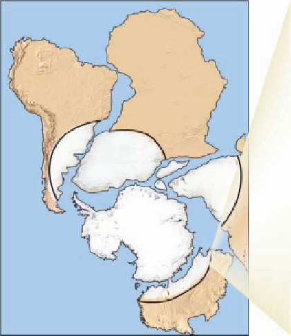
Figure 2.5
Glacial Evidence Indicating Continental Drift
Africa
South America
South
Pole
India
Antarctica
Australia
When the Gondwana continents are placed
together so that South Africa is located at the
South Pole, the glacial movements indicated by
striations (red arrows) found on rock outcrops
on each continent make sense. In this situation,
the glacier (white area) is located in a polar
climate and has moved radially outward from
its thick central area toward its periphery.
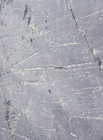
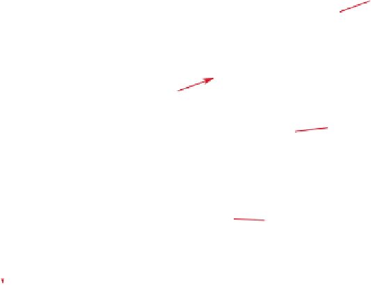
Glacial striations (scratch marks) on an outcrop
of Permian-age bedrock exposed at Hallet's Cove,
Australia, indicate the general direction of glacial
movement more than 200 million years ago. As a
glacier moves over a continent's surface, it grinds
and scratches the underlying rock. The scratch marks
that are preserved on a rock's surface (glacial
striations) thus provide evidence of the direction (red
arrows) the glacier moved at that time.
a
b


Search WWH ::

Custom Search