Geology Reference
In-Depth Information
◗
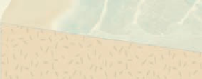
Figure 16.7
Rip Currents
a
Rip currents are fed on each side
by currents moving parallel to the
shoreline.
Breaker
zone
High wave
crests
Low wave
crests
Rip current
b
Suspended sediment, indicated by discolored
water, is being carried seaward in these rip currents.
c
Sign along the California coast warning swimmers of dangerous rip currents,
higher than normal (sleeper) waves, and backwash.
the abrasive planing action of waves is effective to a depth
of only about 10 m. The sediment eroded from sea cliffs
is transported seaward until it reaches deeper water at
the edge of the wave-cut platform. There it is deposited
and forms a
wave-built platform
, which is a seaward exten-
sion of the wave-cut platform (Figure 16.9). Wave-cut plat-
forms now above sea level are known as
marine terraces
(Figure 16.9b).
In the long run, shoreline processes tend to straighten
an initially irregular shoreline. Wave refraction causes more
wave energy to be expended on headlands and less on em-
bayments. Thus, headlands erode, and some of the sediment
yielded by erosion is deposited in the embayments.
In a previous section, we mentioned that longshore currents
are effective at transporting sediment, and indeed they are.
In fact, we can think of the area from the breaker zone to
the upper limit of wave swash as a “river” that fl ows along
the shoreline. Unlike rivers on land, though, its direction of
fl ow changes if waves approach from a different direction.
Nevertheless, the analogy is apt, and just like rivers on land,
a longshore current's capacity for transport varies with fl ow
velocity and water depth.
Wave refraction and the resulting longshore currents are
the primary agents of sediment transport and deposition on
shorelines, but tides also play a role because, as they rise and
Sea cliffs do not retreat uniformly because some of the
materials of which they are composed are more resistant
to erosion than others.
Headlands
are seaward-projecting
parts of the shoreline that are eroded on both sides by wave
refraction (
Figure 16.10).
Sea caves
form on opposite sides
of a headland, and if these caves join, they form a
sea arch
(Figure 16.10a, b). Continued erosion causes the span of
an arch to collapse, creating isolated
sea stacks
on wave-cut
platforms (Figure 16.10a, c).
◗


Search WWH ::

Custom Search