Geology Reference
In-Depth Information
or blowout. As the wind trans-
ports the sand out of the de-
pression, it builds up on the
convex downwind dune crest.
The central part of the dune
is excavated by the wind, while
vegetation holds the ends and
sides fairly well in place.
Another type of dune
commonly found in the des-
erts of North Africa and Saudi
Arabia is the
star dune,
so
named because of its resem-
blance to a multipointed star
(
Figure 15.14). Star dunes are
among the tallest in the world,
rising, in some cases, more than
100 m above the surrounding
desert plain. They consist of
pyramidal hills of sand, from
which radiate several ridges of
sand, and they develop where
the wind direction is variable.
Star dunes can remain station-
ary for centuries at a time and have served as desert land-
marks for nomadic peoples.
◗
◗
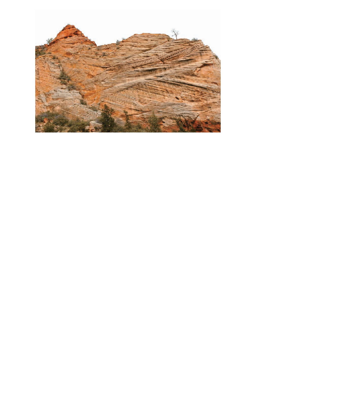
Figure 15.9
Cross-Bedding Ancient cross-bedding in sandstone beds in Zion National Park,
Utah, helps geologists determine the prevailing direction of the wind that formed these ancient
sand dunes.
direction. Most barchans are small, with the largest reach-
ing about 30 m high. Barchans are the most mobile of the
major dune types, moving at rates that can exceed 10 m
per year.
Longitudinal dunes
(also called
seif dunes
) are long, par-
allel ridges of sand aligned generally parallel to the direction
of the prevailing winds; they form where the sand supply is
somewhat limited (
Wind-blown silt and clay deposits composed of angular
quartz grains, feldspar, micas, and calcite are known as
loess.
The distribution of loess shows that it is derived from three
main sources: deserts, Pleistocene glacial outwash deposits,
and the floodplains of rivers in semiarid regions. Loess
must be stabilized by moisture and vegetation in order to
accumulate. Consequently, loess is not found in deserts, even
though deserts provide much of its material. Because of its
unconsolidated nature, loess is easily eroded, and as a result,
eroded loess areas are characterized by steep cliffs and rapid
lateral and headward stream erosion (
Figure 15.11). Longitudinal dunes re-
sult when winds converge from slightly different directions
to produce the prevailing wind. They range in height from
about 3 m to more than 100 m, and some stretch for more
than 100 km. Longitudinal dunes are especially well devel-
oped in central Australia, where they cover nearly one-fourth
of the continent. They also cover extensive areas in Saudi
Arabia, Egypt, and Iran.
Transverse dunes
form long ridges perpendicular to the
prevailing wind direction in areas that have abundant sand
and little or no vegetation (
◗
Figure 15.15).
At present, loess deposits cover approximately 10% of
Earth's land surface and 30% of the United States. The most
extensive and thickest loess deposits are found in north-
east China, where accumulations greater than 30 m thick
are common. The extensive deserts in central Asia are the
source for this loess. Other important loess deposits are
on the North European Plain from Belgium eastward to
Ukraine, in Central Asia, and the Pampas of Argentina.
In the United States, loess deposits are found in the Great
Plains, the Midwest, the Mississippi River Valley, and eastern
Washington state.
Loess-derived soils are some of the world's most
fertile (Figure 15.15). It is therefore not surprising that the
world's major grain-producing regions correspond to large
loess deposits, such as the North European Plain, Ukraine,
and the Great Plains of North America.
◗
Figure 15.12). When viewed
from the air, transverse dunes have a wavelike appearance
and are therefore sometimes called
sand seas.
The crests of
transverse dunes can be as high as 200 m, and the dunes
may be as wide as 3 km. Some transverse dunes develop a
clearly distinguishable barchan form and may separate into
individual barchan dunes along the edges of the dune fi eld
where there is less sand. Such intermediate-form dunes are
known as
barchanoid dunes.
Parabolic dunes
are most common in coastal areas
with abundant sand, strong onshore winds, and a partial
cover of vegetation (
◗
Figure 15.13). Although parabolic
dunes have a crescent shape like barchan dunes, their tips
point upwind. Parabolic dunes form when the vegetation
cover is broken and defl ation produces a defl ation hollow
◗
Search WWH ::

Custom Search