Geology Reference
In-Depth Information
◗
for irrigation in the United States
(
Figure 13.11
Cave Formation
Figure 13.13).
Significant withdrawal of
groundwater from the High
Plains aquifer for irrigation be-
gan in the 1950s, and by 1980, the
water table had dropped an aver-
age of 3 meters. Irrigation from
the High Plains aquifer is largely
responsible for the region's agri-
cultural productivity, including
a significant percentage of the
nation's corn, cotton, and wheat,
and half of U.S. beef cattle.
Although the High Plains
aquifer has contributed to the
high productivity of the region,
it cannot continue to provide
the quantities of water that it
has in the past. Based on the
present rate of groundwater
withdrawal, a 1982 Department
of Commerce study estimated
that by 2020, about a fourth of
the High Plains aquifer water
will have been withdrawn. In
some parts of the High Plains,
from 2 to 100 times more
water is being pumped annu-
ally than is being recharged,
causing a substantial drop in
the water table in many areas
(Figure 13.13). It must be noted
that much of the aquifer's water
infi ltrated during wetter glacial
climates more than 10,000 years
ago. Consequently, most of the
water being pumped is fossil
water that is not being replen-
ished at anywhere near the same
rate when it formed during the
Pleistocene Epoch.
What will happen to this
region's economy if long-term
withdrawal of water from the
High Plains aquifer continues
to greatly exceed its recharge
rate, and the aquifer can no
longer supply the quantities
of water necessary for irriga-
tion? Solutions range from go-
ing back to farming without
irrigation to diverting water from other regions such as
the Great Lakes. Most users of the aquifer realize that they
cannot continue to withdraw the quantities of ground-
water that they have in the past, and thus are turning to
greater conservation, monitoring of the aquifer, and using
◗
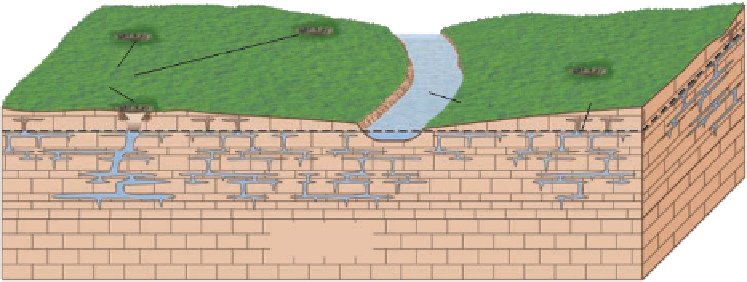
Sinkholes
Water table
Stream
Limestone
a
As groundwater percolates through the zone of aeration and fl ows through the zone of
saturation, it dissolves the carbonate rocks and gradually forms a system of passageways.
Sinkholes
Water table
b
Groundwater moves along the surface of the water table, forming a system of horizontal
passageways through which dissolved rock is carried to the surface streams, thus enlarging the
passageways.
Column
Travertine
terrace
Soda straws
Stalactite
Drip
curtain
Stalagmite
Collapse
blocks
Water table
Sinkhole
Cave
c
As the surface streams erode deeper valleys, the water table drops and the abandoned
channelways form an interconnecting system of caves and caverns.
underlies more than 450,000 km
2
, including most of
Nebraska, large parts of Colorado and Kansas, portions
of South Dakota, Wyoming, and New Mexico, as well
as the panhandle regions of Oklahoma and Texas, and
accounts for approximately 30% of the groundwater used


Search WWH ::

Custom Search