Geology Reference
In-Depth Information
Sinkholes also form when a cave's roof collapses, usually
producing a steep-sided crater. Sinkholes formed in this way
are a serious hazard, particularly in populated areas. In re-
gions prone to sinkhole formation, extensive geologic and
hydrogeologic investigation must be performed to determine
the depth and extent of underlying cave systems prior to any
site development. This is necessary to ensure that the under-
lying rocks are thick enough to support planned structures.
Karst topography
, or simply
karst
, develops largely by
groundwater erosion in many areas underlain by soluble
rocks (
soluble rock at the surface or just below the soil, and enough
water for solution activity to occur (see Geo-inSight on
pages 336 and 337). Karst topography is therefore typically
restricted to humid and temperate climates.
Caves are perhaps the most spectacular examples of the
combined effects of weathering and erosion by groundwater.
As groundwater percolates through carbonate rocks, it dis-
solves and enlarges fractures and openings to form a com-
plex interconnecting system of crevices, caves, caverns, and
underground streams. A
cave
is usually defi ned as a naturally
formed subsurface opening that is generally connected to the
surface and is large enough for a person to enter. A
cavern
is
a very large cave or a system of interconnected caves.
More than 17,000 caves are known in the United States.
Most of them are small, but some are large and spectacular.
Some of the more famous ones are Mammoth Cave, Ken-
tucky, Carlsbad Caverns, New Mexico, Lewis and Clark Cav-
erns, Montana, Lehman Cave, Nevada, and Meramec Caverns,
Missouri, which Jesse James and his outlaw band often used
as a hideout. The United States has many famous caves, but so
has Canada, including 536-m-deep Arctomys Cave in Mount
Robson Provincial Park, British Columbia, the deepest known
cave in North America.
Caves and caverns form as a result of the dissolution of
carbonate rocks by weakly acidic groundwater (
Figure 13.9). The name
karst
is derived from the
plateau region of the border area of Slovenia, Croatia, and
northeastern Italy where this type of topography is well
developed. In the United States, regions of karst topogra-
phy include large areas of southwestern Illinois, southern
Indiana, Kentucky, Tennessee, northern Missouri, Alabama,
and central and northern Florida (Figure 13.7).
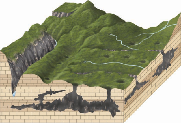
Karst topography is characterized by numerous caves,
springs, sinkholes, solution valleys, and disappearing streams
(Figure 13.9).
Disappearing streams
are so named because
they typically fl ow only a short distance at the surface and
then disappear into a sinkhole. The water continues flow-
ing underground through fractures or caves until it surfaces
again at a spring or other stream.
Karst topography varies from the spectacular high-relief
landscapes of China to the subdued and pockmarked land-
forms of Kentucky (
◗
Figure 13.10). Common to all karst
topography, though, is the presence of thick-bedded, readily
◗
Figure 13.11).
Groundwater percolating through
the zone of aeration slowly dis-
solves the carbonate rock and en-
larges its fractures and bedding
planes. On reaching the water table,
the groundwater migrates toward
the region's surface streams. As the
groundwater moves through the
zone of saturation, it continues
to dissolve the rock and gradually
forms a system of horizontal pas-
sageways through which the dis-
solved rock is carried to the streams.
As the surface streams erode deeper
valleys, the water table drops in
response to the lower elevation of
the streams. The water that fl owed
through the system of horizontal
passageways now percolates to the
lower water table where a new sys-
tem of passageways begins to form.
The abandoned channelways form
an interconnecting system of caves
and caverns. Caves eventually be-
come unstable and collapse, litter-
ing the fl oor with fallen debris.
When most people think of
caves, they think of the seemingly
endless variety of colorful and
◗
Solution valleys
Springs
Sinkholes
Deeply entrenched
permanent stream
Disappearing
streams
Cave
◗
Figure 13.9
Features of Karst Topography Erosion of soluble rock by groundwater produces karst
topography. Features commonly found include solution valleys, springs, sinkholes, and disappearing
streams.

Search WWH ::

Custom Search