Geology Reference
In-Depth Information
from areas where the water table is high toward areas where it
is lower, such as streams, lakes, or swamps. Only some of the
water follows the direct route along the slope of the water table.
Most of it takes longer curving paths down and then enters a
stream, lake, or swamp from below, because it moves from ar-
eas of high pressure toward areas of lower pressure within the
saturated zone.
Groundwater velocity varies greatly and depends on
many factors. Velocities range from 250 m per day in some
extremely permeable material to less than a few centimeters
per year in nearly impermeable material. In most ordinary
aquifers, the average velocity of groundwater is a few
centimeters per day.
swamps, where it discharges at the surface as
springs
, and
where it is withdrawn from the system at water wells.
Places where groundwater fl ows or seeps out of the ground
as
springs
have always fascinated people. The water fl ows out
of the ground for no apparent reason and from no readily
identifi able source. So it is not surprising that springs have
long been regarded with superstition and revered for their
supposed medicinal value and healing powers. Nevertheless,
there is nothing mystical or mysterious about springs.
Although springs can occur under a wide variety of
geologic conditions, they all form in basically the same way
(
Figure 13.4a). When percolating water reaches the water
table or an impermeable layer, it fl ows laterally, and if this
fl ow intersects the surface, the water discharges as a spring
(Figure 13.4b). The Mammoth Cave area in Kentucky is
underlain by fractured limestones whose fractures have been
enlarged into caves by solution activity. In this geologic envi-
ronment, springs occur where the fractures and caves inter-
sect the ground surface, allowing groundwater to exit onto
the surface. Most springs are along valley walls where streams
have cut valleys below the regional water table.
Springs can also develop wherever a perched water table
intersects the surface (Figure 13.3). A
perched water table
may
occur wherever a local aquiclude is present within a larger
aquifer, such as a lens of shale within sandstone. As water
migrates through the zone of aeration, it is stopped by the
local aquiclude, and a localized zone of saturation “perched”
◗
AND ARTESIAN SYSTEMS
You can think of the water in the zone of saturation much
like a reservoir whose surface rises or falls depending on
additions as opposed to natural and artifi cial withdrawals.
Recharge
—that is, additions to the zone of saturation—
comes from rainfall or melting snow, or water might
be added artificially at wastewater-treatment plants or
recharge ponds constructed for just this purpose. But if
groundwater is discharged naturally or withdrawn at wells
without sufficient recharge, the water table drops just as a
savings account diminishes if withdrawals exceed depos-
its. Withdrawals from the groundwater system take place
where groundwater flows laterally into streams, lakes, or
◗
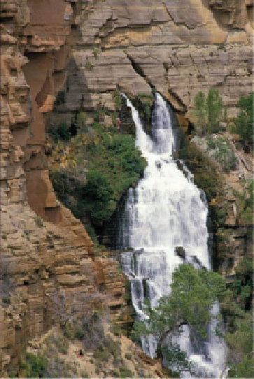
Figure 13.4
Springs Springs form wherever laterally moving
groundwater intersects Earth's surface.
Springs
Permeable
sandstone
beds
Impermeable
shale beds
a
Most commonly, springs form when percolating water reaches an
impermeable layer and migrates laterally until it seeps out at the surface.
b
Thunder River Spring in the Grand Canyon, Arizona, issues from
rocks along a wall of the Grand Canyon. Water percolating downward
through permeable rocks is forced to move laterally when it encounters
an impermeable zone, and thus gushes out along this cliff. Notice the
vegetation parallel to and below the springs, indicating enough water
fl ows from springs along the cliff wall to support the vegetation.


Search WWH ::

Custom Search