Geology Reference
In-Depth Information
◗
◗
Figure 12.24
Two Stages in the Evolution of a Valley
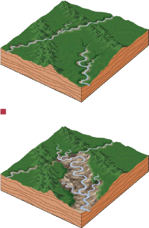
Figure 12.25
Idealized Stages in the Development of a Stream
and Its Associated Landform
Waterfall
Rapids
a
Initial stage
a
The stream widens its valley by lateral erosion and mass wasting
while simultaneously extending its valley by headward erosion.
Floodplain
b
Intermediate stage
b
As the larger stream continues to erode headward, stream piracy
takes place when it captures some of the drainage of the smaller
stream. Notice also that the valley is wider in (b) than it was in (a).
Although all stream terraces result from erosion, they
are preceded by an episode of floodplain formation and
sediment deposition. Subsequent erosion causes the stream
to cut downward until it is once again graded (Figure 12.26).
Then it begins to erode laterally and establishes a new fl ood-
plain at a lower level. Several such episodes account for the
multiple terrace levels adjacent to some channels.
Renewed erosion and the formation of stream terraces
are usually attributed to a change in base level. Either uplift
of the land that a stream fl ows over or lowering of sea level
yields a steeper gradient and increased fl ow velocity, thus ini-
tiating an episode of downcutting. When the stream reaches
a level at which it is once again graded, downcutting ceases.
Although changes in base level no doubt account for many
stream terraces, greater runoff in a stream's drainage basin
can also result in the formation of terraces.
Natural levee
c
Advanced stage
meanders.
For example, the Colorado River in Utah occupies
a meandering canyon more than 600 m deep (
Figure 12.27).
Streams restricted by rock walls usually cannot erode laterally;
thus, they lack a fl oodplain and occupy the entire width of the
canyon fl oor.
It is not difficult to understand how a stream can cut
downward into rock, but how a stream forms a meandering
pattern in bedrock is another matter. Because lateral ero-
sion is inhibited once downcutting begins, one must infer
that the meandering course was established when the stream
fl owed across an area covered by alluvium. For example, sup-
pose that a stream near base level has established a meander-
ing pattern. If the land that the stream fl ows over is uplifted,
then erosion begins and the meanders become incised into
the underlying bedrock.
◗
Some streams are restricted to deep, meandering canyons
cut into bedrock, where they form features called
incised


Search WWH ::

Custom Search