Geology Reference
In-Depth Information
?
◗
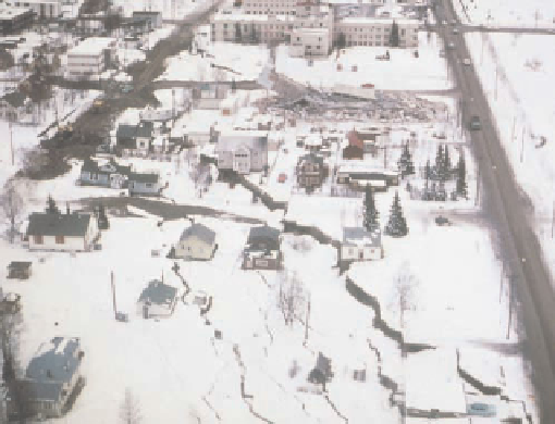
Figure 11.18
Quick-Clay Slide, Anchorage, Alaska
What Would You Do
Turnagain
Heights
Glacial
outwash
Glacial
till
You've found your dream parcel of land in the hills of northern
Baja California, where you plan to retire someday. Because
you want to make sure that the area is safe to build a house,
you decide to do your own geologic investigation of the area
to make sure that there aren't any obvious geologic hazards.
What specifi c things would you look for that might indicate
mass wasting in the past? Even if there is no obvious
evidence of rapid mass wasting, what features would you
look for that might indicate a problem with slow types of
mass wasting such as creep?
Direction of groundwater
movement
Bootlegger
Cove Clay
Ground shaking by the 1964 Alaska earthquake turned parts of
the Bootlegger Cove Clay into a quick clay, causing numerous slides.
a
possible mass wasting before construction begins, engineers
can take steps to eliminate or minimize the effects of such
events.
Identifying areas with a high potential for slope failure
is important in any hazard assessment study; these stud-
ies include identifying former landslides, as well as sites of
potential mass movement. Scarps, open fissures, displaced
or tilted objects, a hummocky surface, and sudden changes
in vegetation are some of the features that indicate former
landslides or an area susceptible to slope failure. The effects
of weathering, erosion, and vegetation may, however, obscure
the evidence of previous mass wasting.
Soil and bedrock samples are also studied, in both the
fi eld and laboratory, to assess such characteristics as com-
position, susceptibility to weathering, cohesiveness, and
ability to transmit fluids. These studies help geologists
and engineers predict slope stability under a variety of
conditions.
The information derived from a hazard assessment
study can be used to produce
slope-stability maps
of the
area (
Low-altitude photograph of the Turnagain Heights subdivision
of Anchorage shows some of the numerous landslide fi ssures that
developed, as well as the extensive damage to buildings in the area.
The remains of the Four Seasons apartment building can be seen in
the background.
b
Figure 11.24). These maps allow planners and de-
velopers to make decisions about where to site roads, util-
ity lines, and housing or industrial developments based on
the relative stability or instability of a particular location.
In addition, the maps indicate the extent of an area's land-
slide problem and the type of mass movement that may
occur. This information is important for grading slopes or
building structures to prevent or minimize slope-failure
damage.
Finally, building codes, which spell out what types of
site investigations need to be made and the manner in which
structures must be built also help determine how land will
be developed and utilized. Of particular interest to us is the
section of the
Uniform Building Code
(UBC, Chapter 70) that
deals with slopes and the alteration of the landscape. This
chapter deals with such geologic situations as the slope angle
and direction of the slope in relation to bedding planes, folia-
tion, faults, and joints, for example. In addition, it also specifi es
surface drainage requirements and compaction of materials
in the area under investigation. This section of the
Uniform
Building Code
has been widely adopted by many counties and
◗
A
debris avalanche
is a complex movement that often oc-
curs in very steep mountain ranges. Debris avalanches typi-
cally start out as rockfalls when large quantities of rock, ice,
and snow are dislodged from a mountainside, frequently as
a result of an earthquake. The material then slides or fl ows
down the mountainside, picking up additional surface ma-
terial and increasing in speed. The 1970 Peru earthquake
(Table 11.1) set in motion the debris avalanche that destroyed
the towns of Yungay and Ranrahirca, Peru, and killed more
than 25,000 people (
◗
Figure 11.23).
EFFECTS OF MASS WASTING
The most important factor in eliminating or minimizing
the damaging effects of mass wasting is a thorough geologic
investigation of the region in question. In this way, former
landslides and areas susceptible to mass movements can
be identifi ed and perhaps avoided. By assessing the risks of


Search WWH ::

Custom Search