Geology Reference
In-Depth Information
because only in recent decades has instrumentation been
available to study this largely hidden domain.
AND COMPOSITION
We have mentioned that oceanic crust is composed of ba-
salt and gabbro and is generated continuously at spreading
ridges. Of course, drilling into the oceanic crust provides
some details about its composition and structure, but it
has never been completely penetrated and sampled. So how
do we know what it is composed of and how it varies with
depth? Actually, even before it was sampled and observed,
these details were known.
Remember that oceanic crust is consumed at subduction
zones and thus most of it is recycled, but a small amount is
found in mountain ranges on land where it was emplaced by
Hydrophone
Sound
source
Echo
sounding
Seismic
reflection
Ocean floor
Sub-bottom sedimentary layers
◗
Figure 9.3
Echo Sounding and Seismic Profi ling Diagram
showing how echo sounding and seismic profi ling are used to study
the seafl oor. With seismic profi ling, the energy generated at the
energy source is refl ected from various horizons back to the surface,
where it is detected by hydrophones.
surface (Figure 9.3). Seismic profi ling is particularly useful
for determining the structure of the oceanic crust where it is
buried beneath seafl oor sediments.
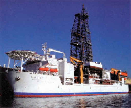
An international program called the Deep Sea Drilling
Project began in 1968 with its research vessel the
Glomar
Challenger
, but after 15 years of oceanographic research, it
was replaced by the Ocean Drilling Program's research vessel
JOIDES*
Resolution.
Both vessels were equipped to drill into
the seafl oor and retrieve samples of sediment and oceanic
crust. Then, in 2003, the responsibilities passed to an even
larger research vessel, the R/V
Chikyu
(“Earth”), a Japanese
ship that can drill as much as 11 kilometers into the seafl oor
(
Figure 9.4a).
In addition to surface vessels, submersibles are also used
extensively in oceanographic research. One of the most fa-
mous of these is
Alvin
, which has carried scientists to the sea-
fl oor in many areas to make observations and collect samples
(Figure 9.4b). Other submersibles are remotely controlled and
towed by surface ships. In 1985, the
Argo
, equipped with sonar
and radar systems, provided the fi rst views of the British ocean
liner HMS
Titanic
since it sank after hitting an iceberg in 1912
(
◗
a
The R/V
Chikyu
(“Earth”), a research ship in the Integrated
Ocean Drilling Program.
Figure 9.5). Another remotely operated submersible, the
Kaiko
, operated by the Japanese, has descended to the greatest
oceanic depths.
Scientifi c investigations have yielded important infor-
mation about the oceans for more than 200 years, but much
of our current knowledge has been acquired since World
War II (1939-1945). This is particularly true of the seafl oor
◗
Image not available due to copyright restrictions
*JOIDES is an acronym for Joint Oceanographic Institutions for Deep
Earth Sampling.
◗
Figure 9.4
Oceanographic Research Vessels


Search WWH ::

Custom Search