Geology Reference
In-Depth Information
c
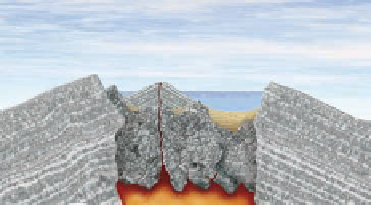
The collapse
of the summit
into the partially
drained magma
chamber forms
a huge caldera.
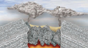
a
Eruption
begins as huge
quantities of ash
are ejected from
the volcano.
Mt. Mazama volcano
(elevation about
3500 meters)
Magma
chamber
b
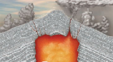
The eruption
continues as
more ash and
pumice are
ejected into
the air and
pyroclastic fl ows
move down the
fl anks of the
mountain.
d
Postcaldera
eruptions
partly cover the
caldera fl oor,
and the small
cinder cone
called Wizard
Island forms.
Rim of Crater Lake
caldera (elevation
2000 meters)
Wizard island
e
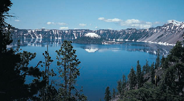
View from the rim of Crater Lake
showing Wizard Island. The lake is 594 m
deep, making it the second deepest in
North America.
◗
Figure 5.9
The Origin of Crater Lake, Oregon Remember, Crater Lake is actually a caldera that
formed by partial draining of a magma chamber.
its base and stands more than 9.5 km above the surrounding
seafl oor; it has a volume estimated at 50,000 km
3
, making it
the world's largest volcano.
Small, steep-sided
cinder cones
made up of particles resem-
bling cinders form when pyroclastic materials accumulate
around a vent from which they erupted (see Geo-inSight on
pages 120 and 121). Cinder cones are small, rarely exceeding
400 m high, with slope angles up to 33 degrees, depending
on the angle that can be maintained by the angular pyro-
clastic materials. Many of these small volcanoes have a
large, bowl-shaped crater, and if they issue any lava fl ows,
they usually break through the base or lower fl anks of the
mountains. Although all cinder cones are conical, their
symmetry varies from those that are almost perfectly sym-
metrical to those that formed when prevailing winds caused
pyroclastic materials to build up higher on the downwind
side of the vent.
Many cinder cones form on the flanks or within the
calderas of larger volcanoes and represent the fi nal stages of
activity, particularly in areas of basaltic volcanism. Wizard
Island in Crater Lake, Oregon, is a small cinder cone that
formed after the summit of Mount Mazama collapsed to
form a caldera (Figure 5.9). Cinder cones are common in the
southern Rocky Mountain states, particularly New Mexico
and Arizona, and many others are in California, Oregon, and
Washington.
In 1973, on the Icelandic island of Heimaey, the town
of Vestmannaeyjar was threatened by a new cinder cone.
The initial eruption began on January 23, and within two
days, a cinder cone, later named Eldfell, rose to about 100 m
above the surrounding area (
Figure 5.10). Pyroclastic
materials from the volcano buried parts of the town, and
by February, a massive aa lava fl ow was advancing toward
the town. The fl ow's leading edge ranged from 10 to 20 m
thick, and its central part was as much as 100 m thick. The
residents of Vestmannaeyjar sprayed the leading edge of the
fl ow with seawater in an effort to divert it from the town.
The fl ow was in fact diverted, but how effective the efforts
of the townspeople were is not clear; they may have been
simply lucky.
◗


Search WWH ::

Custom Search