Geoscience Reference
In-Depth Information
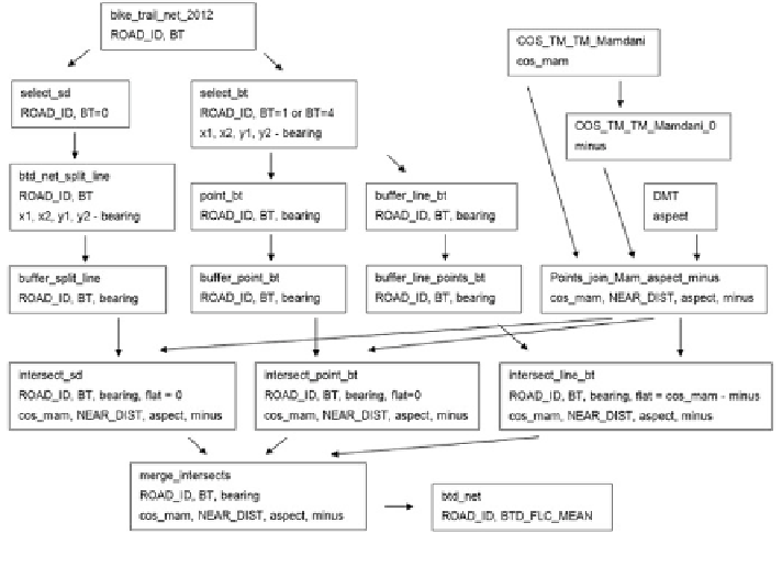
Fig. 17 Scheme for analysis by Python
—
layers and their important attributes
raster which doesn
'
t consider the altitude. This difference in
fl
uences the increase of
the road dif
culty compared to the
fl
flat surface. These steps are implemented by
—
ModelBuilder and point
feature class
is
the result
feature
class called
Points_join_Mam_aspect_minus in Fig.
17
.
The next part takes open-source programming language Python that is both
powerful and easy to learn. Particular steps are re
fl
ected in the following scheme
(Fig.
17
) where these components are used.
Explanatory text:
bike_trail_net_2012
input feature class involving street net and bike trail
sections with actual
fields
select_sd
selection of bike trails except bridges and tunnels
btd_net_split_line
seperation of bike trail sections to line segments, new
geometry and completion bearing attribute (azimuth)
buffer_split_line
10 m buffer of the line segments, bearing (line azimuth)
select_bt
selection of bridges and tunnels
point_bt
beginnings and endings of bridges and tunnels
buffer_point_bt
10 m buffer of endpoints of bridges and tunnels
buffer_line_bt
10 buffer of line of bridges and tunnels
buffer_line_points_bt
symmetrical difference buffer_line_bt and buffer_point_bt
intersect_sd
intersect buffer_split_line and Points_join_Mam_aspect_
minus
intersect_point_bt
intersect buffer_point_bt and Points_join_Mam_aspect_
minus
Search WWH ::

Custom Search