Geoscience Reference
In-Depth Information
the position of their footprints and the shape of these footprints can be used for the
exact determination of the buildings outer walls. The roof planes can be detected by
using ground plan lines. The assumption is that the normal direction of roof planes
is usually perpendicular to one of the ground plane lines [
2
4
]. The shape of
the building outline can be used for a decomposition of a building as a combination
of simple roof elements [
5
-
7
].
The combination of different data sources is a great idea for solving complex
tasks. Many countries have digital cadastral maps and it is therefore possible to use
ground plans for 3D city modelling. Unfortunately, additional data sources like
digital ground plans are not available for every country. Supporting data can be also
outdated in relation to the time of acquisition of elevation data or can come from
untrusted sources. The use of maps is also problematic. The positions of buildings
are known with some uncertainties due to map inaccuracy and generalization. These
uncertainties are not higher than 0.5 m [
8
], however, they strongly depend on
the quality and scale of the maps. The original form of the maps (digital or paper) is
also important.
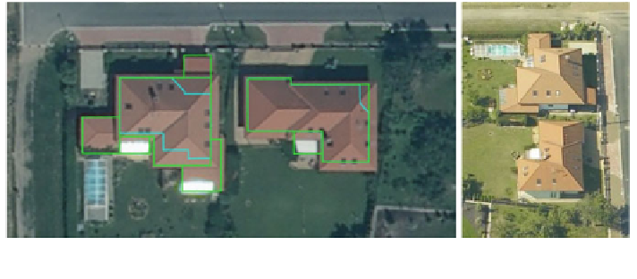
Using ground plans can be often quite complicated. Ground plans are based on
cadastral maps that register only the outer walls. A large number of buildings have
different shapes of their ground plans and roof footprints. Modern houses have
typically large roof overhangs over the outer walls. It is illustratively presented in
Fig.
1
.
This problem is solved by the Czech Land Survey Of
-
ce. The Czech Republic
has an old cadastral map, which contains many errors as a result of many decades of
a continuous operation. Most users want consistent and especially actual data sets.
Now there is an effort to
fix these errors using point clouds acquired by ALS for the
new altimetry mapping. Automatic detection of buildings can be also used for
updating and revision of the cadastral map and other derived products. Manual
validation of millions of buildings is not feasible from the perspective of the whole
country. It is also necessary to use a very sophisticated full-automatic solution
which is independent on other sources.
Fig. 1 Left Orthoimage of two buildings with roof overhangs (green line) over the outer walls
(cyan line). Right Oblique image of the same buildings taken from the east
Search WWH ::

Custom Search