Information Technology Reference
In-Depth Information
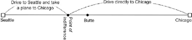
Fig. 4.1
The phenomenon of spatial inversion
4.1.1
Transport Networks Create Distance: A Cartographic
Problem
To understand the present global space, it is necessary to emphasize the major role
played by high travel speeds in the structuring of metropolitan spaces. These high
travel speeds have initiated the development of communications on a global scale.
However, high travel speeds also control a dramatic variety of places.
While this high-speed movement highlights the importance of global communi-
cation, the secondary networks and spaces remain present in the interstices. A key
point in the formation of global time-distances is the fact that these secondary
networks are obsolete, when compared to the main high-speed networks.
How can this complicated set of networks and relations in space be represented?
To answer this question, a broader perspective of the representation of distances
must be considered. In this field, Bunge has stated that two methods are avail-
able: “representing complicated distances on simple maps or representing simple
distances on complicated maps” (
Bunge
,
1962
).
In his classical example of the complicated relations in space generated by
contemporary transportation, Bunge considers the movements from intermediary
space to higher level cities with a trip from a location in Montana to the city of
Chicago (Fig.
4.1
). In this example, the use of the transport modes of cars and
planes, implies that the shortest path in time-space takes a completely different
shape beyond and after a particular point of space. Departing from Butte would
mean driving directly to Chicago, while starting from a location that is closer
to the Pacific Coast involves a trip by car to Seattle, followed by a flight. This
phenomenon of spatial inversion that follows intuitive logic from a transportation
perspective provokes a disturbance in the order of proximities. With regard to
Cauvins's formalism (
1984
), although the Rocky Mountains are located between
Seattle and Chicago in chorotaxic space, which is the normal geographic space,
their position in functional space is different. In the transport space, Seattle stands
between the Rocky Mountains and the Great Lakes.
The identification of the phenomenon of spatial inversion constitutes a key
explanation of the research for new representations of time-space that would render
this complicated set of distances. Allowing for the representation of distances that
would be simpler to read would certainly complicate the map.
Search WWH ::

Custom Search