Geoscience Reference
In-Depth Information
7.6.2
Measurement concepts
From the introduction above, the need for an accurate determination of the
earth's gravity field becomes evident. Three different measurement concepts
evolved, leading to three different gravity field satellite missions:
•
satellite-to-satellite (SST) tracking in high-low mode being realized by
the “Challenging Minisatellite Payload” (CHAMP) mission,
•
satellite-to-satellite tracking in low-low mode being realized by the
“Gravity Recovery and Climate Experiment” (GRACE), and
•
satellite gravity gradiometry, the objective of the “Gravity Field and
Steady State Ocean Circulation Explorer” (GOCE) mission.
Before giving some details on the objectives and payloads of the missions,
the different concepts are briefly described.
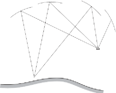
Satellite-to-satellite tracking in high-low mode
The principle is shown in Fig. 7.8. The orbit of the low earth orbit (LEO)
satellite is continuously determined by satellites of global systems such as
GPS, GLONASS or, in the future, Galileo. Note that the term “high-low
mode” is not really appropriate because the satellites of GPS, GLONASS,
and Galileo belong to the mean earth orbit (MEO) satellites and not to the
high earth orbit (HEO) satellites. However, we keep the notation as used in
Seeber (2003: Sect. 10.1). Apart from satellite-to-satellite tracking, the LEO
satellite uses an accelerometer. In principle, three-dimensional perturbing
accelerations caused by the earth's gravity field are measured. These ac-
celerations correspond to first derivatives of the gravitational potential
V
.
GPS satellites
LEO satellite
3D accelerometer
earth's surface
Fig. 7.8. Satellite-to-satellite tracking in high-low mode