Geoscience Reference
In-Depth Information
Range rates
This measurement quantity is found by observing the Doppler effect with
radio waves transmitted from a satellite. It is still used within GPS and in
satellite-to-satellite tracking (SST).
Satellite altimetry
Here a short-wave electronic ray is sent, from a satellite flying over the
oceans, vertically down to the ocean surface, reflected there and received by
the satellite again. The measured travel time immediately gives the height
H
of the satellite above the ocean surface. Knowing the orbital position of
the satellite with respect to the global reference system, we can compute the
satellite height
h
above the ellipsoid. Then the difference
h−H
is the geoidal
height
N
. This is the case if the sea surface is assumed to coincide with the
geoid. In reality, because of ocean currents, etc., both surfaces are separated
by the “sea surface topography”, which may reach the order of 1 m and is
interesting to oceanography. It can be determined if an accurate ocean geoid
is known from the gravitational field.
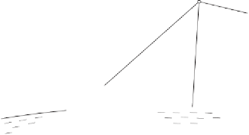
The principles of these methods are illustrated in Fig. 7.1, where
e
indi-
cates the direction observation,
s
between tracking station and satellite refers
to the range measurement, and, accordingly,
ds/dt
corresponds to Doppler
observation, whereas
ds/dt
between the two satellites is obtained by SST;
finally,
H
is measured by satellite altimetry.
satellite
satellite
s
H
tracking
station
e
geoid
W=
0
land
ocean
Fig. 7.1. Principles of satellite techniques