Geoscience Reference
In-Depth Information
of a change in the geodetic datum.
Remark.
The differential formulas could also be replaced by a successive
application of the original finite formulas. Try!
Part II: Three-dimensional geodesy: a transition
5.8
The three-dimensional geodesy of Bruns and
Hotine
The idea of a computation of a triangulation network in space dates back to
Bruns (1878). On the basis of his ideas, Hotine (1969), and earlier in 1959, de-
veloped extensively the concept of a classical (pre-satellite) geodetic network
in a rigorous three-dimensional way. For a comparison, see Levallois (1963).
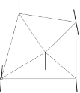
Consider the polyhedron formed by triangulation benchmarks on the sur-
face of the earth and the straight lines of sight connecting them (Fig. 5.10).
Another set of straight lines - one through each corner - represents the
plumb line at the stations.
In order to determine this figure, we need five parameters for each station
- three coordinates and two parameters defining the direction of the plumb
line. The main terrestrial observational data for this purpose are
1. horizontal angles and zenith angles, obtained by theodolite observa-
tions;
2. straight spatial distances, obtained by electronic distance measure-
ments; and
3. astronomical observations of latitude and longitude to fix the direction
of the plumb line, and of azimuth to determine the orientation of the
polyhedron.
Fig. 5.10. Bruns' polyhedron