Geoscience Reference
In-Depth Information
on precipitation, drainage area, land use, land cover, and soil properties. They are
determined by the watershed model.
The daily sediment loads fromupland fields can also be converted to the triangular or
gamma-function sedigraphs, by assuming the sediment discharge to be proportional
to the flow discharge. In addition, the watershed model often gives only fractional
loads for clay, silt, and sand. These three size classes perhaps are too few for channel
simulation and need to be subdivided into more size classes.
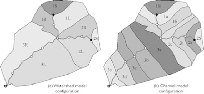
Space scale
Because the watershed and channel models have different computational domains,
a space scale problem exists in the integrated simulation. Fig. 8.14(a) shows the
configuration commonly used in the watershed model, in which a channel usually
starts from a source node or a junction node and ends at the watershed outlet or
another junction node. The subwatersheds are segmented corresponding to the source
nodes and to the left and right sides of channels. The runoff and sediment loads at
each subwatershed are simulated. However, the channels used in the watershed model
are usually too long to be used as computational elements in the channel model and
thus should be subdivided into shorter reaches by adding more computational points,
as shown in Fig. 8.14(b). This requires subdivision of the runoff and sediment loads
from the subwatersheds to the reaches.
Figure 8.14
Computational domains in watershed and channel models.
There are three ways to subdivide the runoff and sediment loads at subwatersheds.
One is to put all loads on the source node or the junction node, i.e., the first node
of each channel. However, this approach may not be accurate enough. The second
way is to distribute the loads uniformly along the channel length. The third way
is to define the subcatchment for each reach and then distribute the loads accord-
ing to the subcatchment area, as shown in Fig. 8.14(b). The third way is the most
reasonable.