Geoscience Reference
In-Depth Information
in New York Harbor. Because most of the harbor is a well-mixed estuary, a depth-
averaged 2-D model was first used to verify the tidal propagation and overall current
velocities, and then a 3-D model was applied using the coefficients from the 2-D
verification as a starting point. This approach worked well since the 2-D model was
used in a large portion of the domain and the 3-D model was only used in a small
region where the flow was highly three-dimensional.
Wu and Li (1992) applied the coupled 1-D and depth-averaged 2-D quasi-steady
model in the study of sedimentation problems in the fluctuating backwater region of
China's Three Gorges Project (TGP) 30 years after the dam's construction. The study
domain included a 176 km long reach in the main stream of the Yangtze River and a
13 km long reach in the Jialing River tributary. The entire study domain was divided
into four 1-D reaches and four 2-D reaches. The simulation results were qualitatively
consistent with the physical model results.
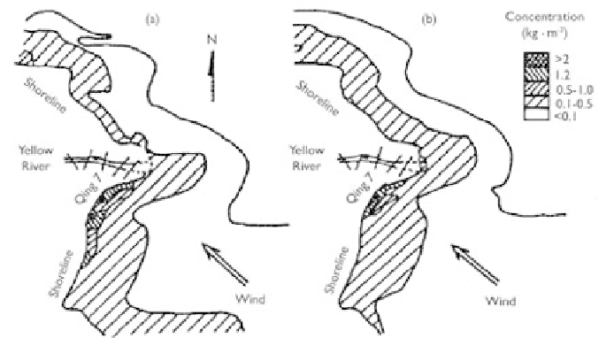
Zhang (1999) applied a 1-D unsteady model to simulate the flow and sediment
transport in the channel and a depth-averaged 2-D unsteady model in the offshore
area near the Yellow River mouth, as shown in Fig. 8.11. The coupled simulation gave
plausible results for sediment concentration and bed deformation under the effects of
runoff, tide, and wind-driven currents and waves.
Figure 8.11
Calculated contours of sediment concentration caused by wind surges near the Yellow
River mouth: (a) flood tide and (b) ebb tide (Zhang, 1999).
8.3 INTEGRATION OF CHANNEL AND WATERSHED
MODELS
Human activities, such as urbanization, agricultural practices, vegetative clearing,
dam construction, and river restoration, affect the equilibrium of watershed-channel
systems. Prediction of these impacts at a watershed scale is very important. Tradition-
ally, this prediction has been split into two parts: watershed and channel simulations,