Graphics Reference
In-Depth Information
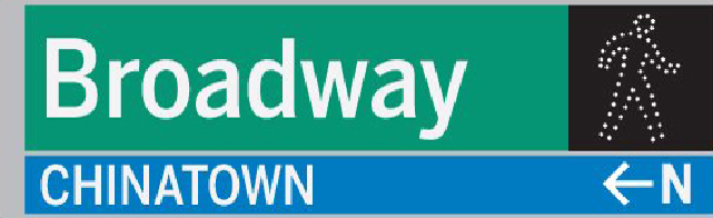
Street sign augmented with pedestrian, directional and neighbourhood information.
• Personal tools: The system should embrace the emergence of handheld devices and
give New York a sophisticated set of digital tools to support navigation.
• Integration with public transportation: The wayfinding system elements are de-
signed to intersect with the public transportation information infrastructure.
• Keys to the city: There is a set of simple navigation rules and insider clues that will
help people understand New York City.
• The living map: A rich geographical information system (GIS) mapping database
will contain the details of the city's geography and wayfinding information. This is
a robust content-management tool to be used for the pedestrian wayfinding system
and other related information publishers. It will also include design standards.
Guiding principles
A set of principles provides the framework for the system and helps to guide the
design of its components and their functions.
• A unified language of wayfinding: The content communicated by the I Walk New
York wayfinding elements should be consistent so that people have a predictable,
seamless and comprehensible experience of the city.
• Wayfinding data organized: The system should be built on a foundation of informa-
tion that is stored and distributed digitally. Individual agencies and neighbourhoods
will update information in the same centralized database, and will use the same
graphic standards in creating maps.
• Wayfinding is more than signs: The system will include a cohesive family of way-
finding elements including fixed signage, publications and digital tools.