Geology Reference
In-Depth Information
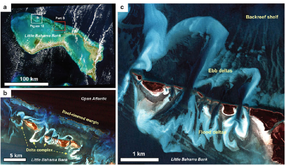
Fig. 20.11
Setting and character of tidal deltas, western Abaco
Islands, Little Bahama Bank. (
a
) Image illustrating location of
tidal delta complex (
red box
) and Lily Bank (
white box
) on
northern margin of Little Bahama Bank. (
b
) Image of the
northern platform margin. Note the reef-rimmed northern mar-
gin, the discontinuous island chain, and the ebb- and fl ood-tidal
deltas. (
c
) Image illustrating details of the ebb- and fl ood-tidal
deltas. Note the discontinuous islands, which restrict fl ow, and
the associated tidal deltas. Rocky ridges form the WNW-ESE
“stripes” in the southern part of this image. Image acquired
3/16/2005 (Image copyright DigitalGlobe.com)
(Reeder and Rankey
2009b
) . This process-response
relationship shows a strong geomorphic similarity with
siliciclastic analogs.
Lily Bank shoal complex
also occurs on the north-
eastern margin of Little Bahama Bank (Fig.
20.11a
)
and covers ~270 km
2
, but, unlike Double Breasted
Cays or the Abaco Tidal Deltas, it is not associated
with any bedrock islands (Hine
1977
; Rankey et al.
2006
). The shoal complex falls along a part of the
margin that has no Pleistocene bedrock exposed above
sea level and is generally unrimmed, although three
discontinuous reef patches along the margin appear to
provide suffi cient lateral fl ow restriction to focus cur-
rents enough to establish an ooid shoal. The complex
includes two downdip systems of radiating tidal sand
ridges (up to 2 m tall, in waters several meters deep)
that radiate outward (Fig.
20.12
, top). These areas are
now largely stabilized by seagrass, and were inter-
preted by Hine (
1977
) to represent earlier Holocene
deposits. As sea-level continued to rise, the active
oolitic shoals of Lily Bank backstepped further
onto the platform, where they form a 4 km-wide
complex that extends up to 15 km onto the platform.
The active shoal complex includes a mix of shoulder
bars and parabolic bars extensively ornamented with
sand waves, formed by the complex patterns of ebb-
and fl ood-tidal currents (Fig.
20.12
, bottom). Shallow
bar crests are ~1 m deep at low tide, and include well-
sorted medium sands with abundant (>90%) ooids;
in contrast, 3-5 m deep channels are composed of
poorly sorted, more peloidal and skeletal sediments,
and include up to 16% mud. The shoals end abruptly,
dipping platformward into waters 5-8 m deep covered
by dense seagrass, with sediments broadly similar to
those in the channels.
At the largest scale, because it backsteps through the
Holocene rather than aggrades (in contrast to Joulter
Cays, see below), this complex illustrates one means
by which shoals may evolve in response to changes in
sediment supply and rising sea level. Similarly, Lily Bank
barforms show that parabolic bars in carbonate systems
can be formed as a result of feedbacks among tidal fl ow,
sediment transport, and geomorphology, and do not
require bedrock highs or storms for their formation