Geology Reference
In-Depth Information
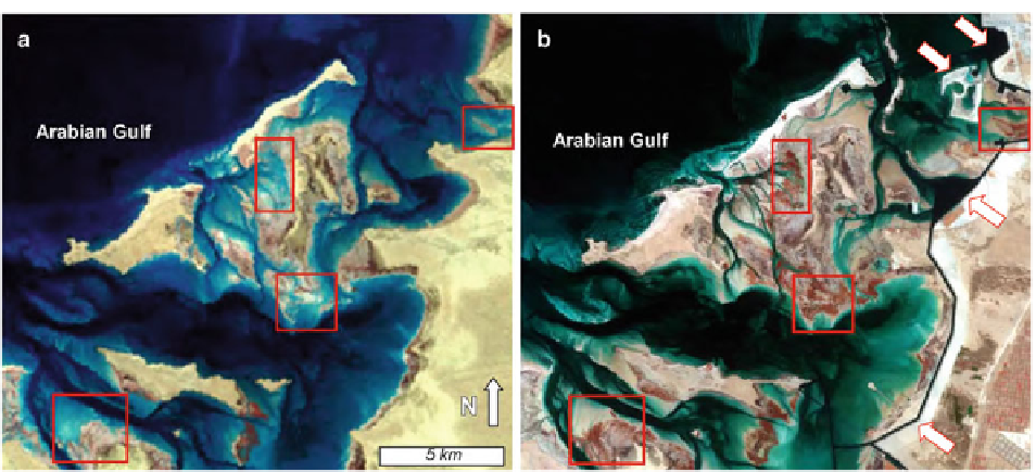
Fig. 19.17
Paired false-color (NIR-G-B) remote sensing
images from area just northeast of Abu Dhabi City (Fig.
19.16
,
illustrating changes between 1972 (
a
) and 2001 (
b
). Although
there are numerous anthropogenic/cultural changes on or near
the terrestrial, mainland shoreline (e.g. the canal highlighted by
the
white arrows
with
red
borders), other more offshore areas
have changed as well. The most obvious changes (highlighted
by the
red boxes
) include sediment aggradation and consequent
expansion of mangrove swamps
1994
; Tedesco and Wanless
1991
; Tedesco and Aller
1997
;
Berkeley and Rankey in review
) . As with pre-
vious sections, our goal is to provide a general fl avor
of the spectrum of types of vertical facies successions
that can occur in carbonate tidal fl ats. Readers inter-
ested in more stratigraphic details for each area
should refer to the primary literature, reviews that
emphasize stratigraphic aspects (e.g., James
1979
;
Shinn
1983a,
b
; Wright
1984
; Hardie
1986
; Pratt
et al.
1992
), or the AAPG movies “Arid Carbonate
Coastlines” (Scholle et al.
2005
) or “Stratigraphic
Traps: The Tidal Flat Model” (Shinn
1981
) which
graphically illustrate many of these features.
occur only sporadically beneath the overlying biotur-
bated subtidal and intertidal mud (Fig.
19.18
), and the
sharp discontinuity separating the freshwater marsh
and overlying subtidal mud may partly refl ect erosion
of the underlying deposits (Hardie and Ginsburg
1977
) .
Where accretion has reached upper intertidal and
supratidal elevations (e.g. beach ridge and levee, crest
and back slopes), the thick (up to 2 m) subtidal and
intertidal mud is overlain by a fi nely laminated
supratidal cap up to 30 cm in thickness. Notably, the
Three Creeks succession shows no clear indication of
systematic seaward progradation or migration of tidal
channels (although some are abandoned), but rather
includes a dominantly aggradational signal. Tidal-fl at
sedimentation appears to have initiated following the
development of an initial shoreline with low energy
conditions in its lee. Sediment accretion has continued,
evolving into the complex of channels, ponds, levees
and mangrove belts observed today (Hardie and
Ginsburg
1977
), driven by tidal creeks which act
essentially as distributary networks.
As discussed above, because there is limited evi-
dence for tidal-channel migration in the Three Creeks
area, and widespread evidence for aggradation and
infi lling within the low-energy ponds, the most likely
stratigraphic product of a “complete” succession would
19.5.1 Three Creeks Area, Andros Island
Approximately 2 m of Holocene sediments overlie
Pleistocene bedrock in the Three Creeks area (Shinn
et al.
1969
). The basal component in many areas con-
sists of thinly-bedded freshwater marsh sediments
(<40 cm thick), which has been identifi ed from cores
from up to 1 km offshore from the contemporary tidal
fl at, indicating a substantial Holocene transgression
(Fig.
19.18
) (Shinn et al.
1969
; Hardie and Ginsburg
1977
). Nonetheless, these freshwater marsh deposits