Geology Reference
In-Depth Information
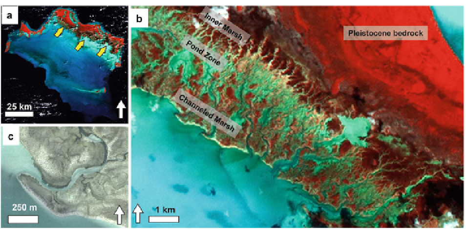
Fig. 19.10
Geomorphic characteristics and setting of the
tidal fl ats of the Caicos platform. (
a
) Image (NIR-G-B) illus-
trating the entire platform, with the location of the most
expansive tidal fl ats on the southern fl anks of the islands
(
arrows
). (
b
) Remote sensing image illustrating general
zonation of part of the tidal-fl at complex. (
c
) Remote sensing
image illustrating the westward bend in a creek near its termi-
nation into the platform interior, related to longshore currents
from easterly winds (Remote sensing image (
c
) copyright
DigitalGlobe)
roughly perpendicular to the coastline, suggesting that
pre-existing bedrock topography strongly infl uences
facies patterns here.
Because of the numerous bedrock highs, this region
lacks a well-defi ned channeled belt like that in the
Three Creeks region. Instead, landward of the shoreline
are a series of subtidal open ponds (Fig.
19.9a
), lower
intertidal mangrove ponds, and scattered algal marshes.
Small supratidal levees and upper intertidal high algal
marshes fl ank some of the larger channels and most of
the hammocks, and slope down to the ponds. Some of
the ponds are large and deep enough to have suffi cient
fetch to develop fl anking grainy beaches (see yellow
arrows in Fig.
19.9a
).
three general geomorphic zones: channeled fl ats, a
pond zone, and an inner marsh (Fig.
19.10b
) (Wanless
et al.
1989
) zone. The shoreline is a low (30-40 cm),
erosional scarp. Relative to the northwest Andros, this
shoreline levee is lower and broader (up to ~1 km
wide) and has less area covered with thinly laminated
Schizothryx
mats. Like the Andros tidal-fl at shoreline,
however, it too includes evidence for basal transgres-
sive deposits. For example, Wanless et al. (
1988a,
b
)
documented that some offshore marine sediments were
underlain by tidal-fl at pond sediments. They also high-
lighted the infl uence of bioturbation in re-working the
sedimentary record of transgression.
Along the shoreline, the mouths of several tidal
channels are offset to the west-northwest due to growth
of spits, presumably driven by the prevailing easterly
wind (Fig.
19.10c
). Sinuous tidal channels extend up to
5 km into the tidal fl at, but are fl anked by lower, broader,
and less well-developed levees than in the
Schizothix
-
dominated levees of the Three Creeks area. Most creeks
extend landward and empty into the pond zone, a region
of shallow ponds continuous along strike. The ponds
are fl anked landward by an inner microbial marsh
1-2 km wide. This marsh is a broad zone dominated by
19.3.2.3 Tidal Flats, Caicos Platform
The best-developed tidal fl ats of the Caicos platform
occur on the low-energy south to southwestern fl anks
of Middle and North Caicos islands. Facies patterns in
this area include subtle variations from those in the
Three Creeks area of Andros Island. As on Andros, the
nearshore is a shallow, highly burrowed subtidal zone
dominated by mud and soft peloidal sand that slopes
gently away from the coast. Tidal fl ats here include