Geology Reference
In-Depth Information
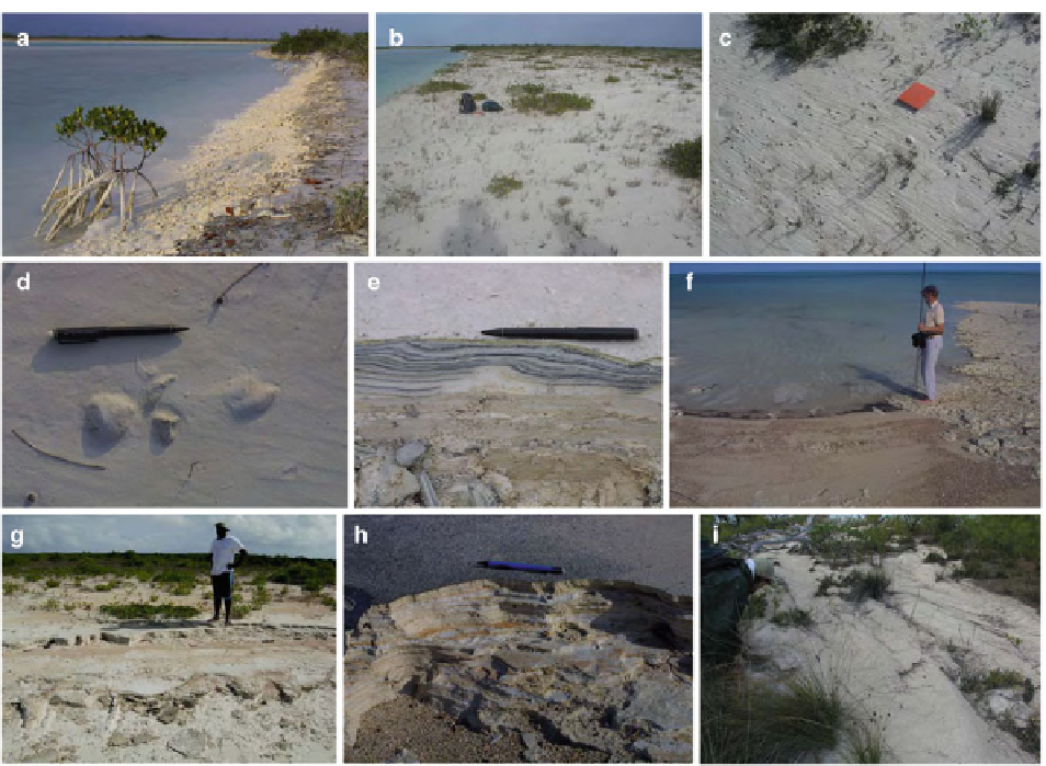
Fig. 19.5
Field photos of representative supratidal environments
and sediments, Bahamian Archipelago. (
a
) Margin of large tidal
creek (
left
) with adjacent levee (
right
), Andros Island. The fl anks
of the levee are extensively burrowed by the fi ddler crab
Uca
.
Mangrove in foreground is ~50 cm tall. (
b
) Supratidal levee
crest, illustrating the relatively sparse vegetation, including only
sparse low shrubs and grasses. Backpacks for scale. Three
Creeks, Andros. (
c
) Close-up of supratidal levee, illustrating the
absence of mudcracks and sparse vegetation, Andros. Field
notebook long axis ~22 cm. Note rill marks formed as fl ooding
tide tops levee. (
d
) Air-fi lled blisters on supratidal levee that
could become fenestrae, Andros Island. Pencil for scale. (
e
) Upper
part of small trench through supratidal levee sediments, Andros
Island, illustrating thinly laminated appearance. Pencil for scale.
Apparent waves in lamination are artifact of irregularities in
trench wall. (
f
) Irregular shoreline, southwest Andros Island. To
the
left
of the observer, the shoreline is sandy, whereas to the
right
, it is made of eroding thinly laminated sediments. (
g
)
Finely laminated sediments eroding at the shoreline, Acklins
Island, Bahamas. (
h
) Close up from (
g
), illustrating the thin
laminations. Pencil for scale. (
i
) Landward-dipping, partly stabi-
lized, sandy deposits on the tidal fl at. These deposits probably
resulted from large (storm) waves on the adjacent beach.
Observer and backpack (to
left
) for scale
Short cores from this area reveal that the sediments
include generally muddy sediment with distinct cm-
scale laminations, thicker than elsewhere on the tidal
fl at (Fig.
19.6d
)
,
likely refl ecting mud settling out from
surges driven by the infrequent, but pronounced, fl ood-
ing associated with hurricanes (Shinn et al.
1969
) .
On parts of southwest Andros tidal fl ats and on the
tidal fl ats south of Crooked Island, bedrock highs pro-
truding above the sediment form another supratidal
environment. Hardie (
1977
) illustrates as much as 3 m
relief on the top of bedrock around these features, and
tidal fl ats of Crooked Island include similar irregularity
on the bedrock surface (
Berkeley and Rankey
, in
review). These features, termed hammocks, have
patchy soil capped with a diverse terrestrial biota,
including grasses, palmettos, and palm trees, as well as
Cerion
, a tree snail (Fig.
19.6e
). These bedrock highs
are ringed by fringes of laminated mud, locally mud-
cracked, with sparse vegetation (Fig.
19.6f
). Many
areas include cemented crusts and locally continuous
pavements. These pavements on Andros are locally
known as “sidewalks” or “runways,” because some are