Geology Reference
In-Depth Information
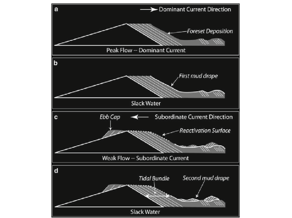
Fig. 14.8
Developmental model for ripple or dune-related mud
couplets. (
a
) During peak fl ow of the dominant current, cross-
strata build (in this case dune-scale, but they could be ripple-scale
or even planar lamination). (
b
) During the subsequent slack-
water, mud drapes the fi nal depositional surface of (
a
). (
c
) The
subordinate current (fl owing in a different direction, but not
necessarily directly opposite to the dominant current) reworks
the previous cross-strata, eroding the upper part but leaving the
lower mud-drape intact, now with some coarser rippled sediment
deposited above it (this could also be planar laminated and fi ner-
grained than that of the dominant current). An ebb cap of rippled
sand also develops on the stoss side of the dune (lee side for the
subordinate current), composed of sediment reworked from the
crest of the dune. (
d
) The succeeding slack-water sees deposi-
tion of a fi nal mud drape, making the mud couplet complete
(Modifi ed from Visser 1980 and Dalrymple
2010
)
(Fig.
14.9
). A clear, albeit noisy, trend of regular
thick-thin alternations and of longer-term symmetrical
thickening and thinning cycles are apparent in the data
(Fig.
14.9c
). Fourier analysis of the thickness data
demonstrates that thick-thin intervals with a period of
2 are very common (Fig.
14.10
). This suggests not
only that the succession is tidal in origin, but that it is
a semi-diurnal tide. Additional peaks at various peri-
ods suggest the tidal regime was infl uenced by a
number of different tidal constituents; possible inter-
pretations of these peaks are shown (Fig.
14.10
).
The Cretaceous Rosario Formation, Baja California,
Mexico, preserves a large volume of upper to middle
continental slope sediments representing submarine
canyon, channel, levee, and open continental slope
depositional settings (Dykstra and Kneller
2007
;
Dykstra and Kneller
2009
; Kane et al.
2009
; Kane
et al.
2007
; Morris
1992
) . The Upper Cretaceous
Cajiloa submarine canyon is incised over 150 m into
the Upper Cretaceous, fl uvial-alluvial el Gallo
Formation (Morris and Busby-Spera
1988
) . Paleo-water
depths in the submarine canyon were bathyal, and it
was probably situated on the upper to mid-continental
slope (Morris and Busby-Spera
1988
) . The submarine
canyon fi ll consists of conglomeratic and sandstone-
dominated channel axis deposits fl anked and overlain