Geology Reference
In-Depth Information
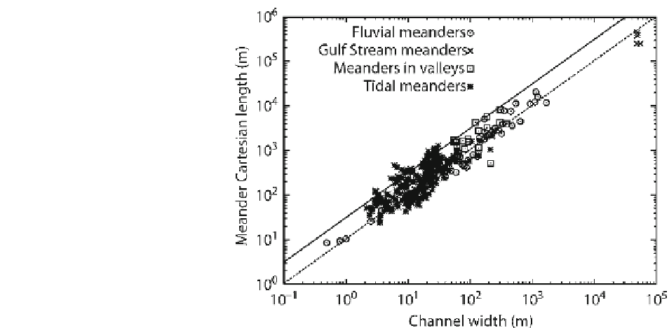
Fig. 11.13
Plot showing the
relationship between meander
wavelength and channel
width (Adapted from Marani
et al.
2002
in Seminara
2006
)
basins, however, when total channel length is compared
to creekshed area as a proxy to prism, the relationship
is more consistent and is of the order S
l
= 0.02
A
. This
implies a constant Hortonian drainage density.
Novakowski et al. (
2004
) fi nd that S
l =
0.03
A
0.88
, based
on analysis of 725 creeksheds in South Carolina, US,
with drainage densities for ranging from 0.0008 to
0.069 m/m
2
(a wider range than is seen in fl uvial sys-
tems 0.0023-0.0137 m/m
2
). Steel and Pye (
1997
) also
see a similar relationship in British salt marshes. The
implication of this is that there may be a common net-
work geometry within marsh systems, potentially an
underlying similarity in branching.
Marani et al. (
2003
) go further to confi rm this
hypothesis by examining the mean length of unchan-
neled pathways (
L
) for a given basin with respect to
creekshed area and the Hortonian characteristic path
length (the inverse of the drainage density;
l
H
=
A
/
S l
).
Hortonian length
l
H
provides a measure of how the
catchment is dissected by the channel network, whereas
L
is essentially the mean distance that fl ow must travel
from a point on the fl ats to reach a channel and indi-
cates how effi ciently the network drains (ebb) or feeds
(fl ood) the creekshed. A direct comparison of these
two parameters does not provide any clear relation-
ship. Further, when the ratio
l
H
/
L
is use as a proxy for
drainage effi ciency (a high value indicating relatively
short unchanneled paths) and is compared to branching
frequency (i.e., the ratio of lower and higher-order
streams), the relationship is also poor. The conclusion
must be that traditional Hortonian drainage density
does not provide a good measure of the variability of
network patterns seen on salt marshes, because unlike
rivers, these systems are not scale invariant.
11.7
Preservation Potential
Preservation of sedimentary deposits formed in tidal
channels may occur vertically and horizontally, through
infi lling and lateral accretion. Reduced tidal prism
because of changing tidal range or modifi cation of the
surrounding tidal system will naturally lead to a
reduction in cross-sectional area and infi lling of the
channel with fi ne-grained sediment (Rieu et al.
2005
) .
An upward fi ning in sediment and change from sandy
to heterolithic or muddy bedding indicates reduction in
fl ow strength and can be observed in both infi lling
channels and where lateral movement of the channel
alters the tidal conditions at a particular point. Dalrymple
et al. (
1992
) suggest that estuarine tidal channels are
continuously infi lling during rising sea level, where
sediment supply is adequate.
Lateral migration of channels produces both lateral and
vertical sedimentation; cut and fi ll facies, which exhibit
upward fi ning sediment over a sharp erosional base
(van Straaten
1954
; Terwindt
1988
) . Figure
11.14
pro-
vides a conceptual sketch of such a succession; the
scale of the channel and bedding would vary according
to hydrodynamic and sedimentary setting.