Geology Reference
In-Depth Information
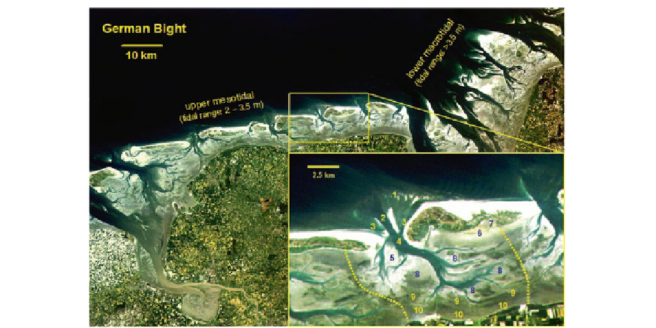
Fig. 10.4
Typical morphological elements of a barrier island
depositional system, here illustrated by an example from the
German Wadden Sea.
1
ebb-delta,
2
main ebb channel,
3
marginal
flood channels,
4
inlet with back-barrier channel system,
5
flood
ramp,
6
overwash fans,
7
back-barrier salt marsh and microbial
mats,
8
sand flats,
9
mixed flats,
10
mud flats,
yellow dotted line
:
tidal watersheds
This is illustrated by an example from the Wadden Sea
(Fig.
10.4
, inset). The depositional system begins on
the seaward side of an inlet with an ebb-delta shoal
(marked 1 in the inset of Fig.
10.4
), which is subdi-
vided by a central ebb channel (2) and marginal flood
channels (3) that converge on the inlet (4). Inlets typi-
cally reach depths of 15-30 m, in exceptional circum-
stances up to 50 m, the depth being highly correlated
with the tidal prism (Oost and de Boer
1994
; van der
Spek
1995
). The same relationship applies to any loca-
tion of the intra-basin channels and the fractional tidal
prism discharging through that location (van der Spek
1995
). In many respects the tidal channel systems
comply with the morphometric rules known from flu-
vial drainage systems (Hack
1957
; Leopold et al.
1964
;
Flemming and Davis
1994
; Rinaldo et al.
2004
).
The tidal drainage systems are cut into what are
known as the back-barrier tidal flats. These can be sub-
divided into a number of morpho-sedimentological
units that reflect particular hydrodynamic processes, in
particular the shoreward decreasing energy gradient.
As evident from Fig.
10.4
, the intertidal flats at low
tide occupy a much larger area than the tidal channels,
a feature that distinguishes these systems from back-
barrier lagoonal systems where the water-covered area
at low tide is much larger than that of the fringing
intertidal flats. It is possibly due to this fact that the
type of back-barrier tidal flat system discussed here
(cf. Fig.
10.4
) does not display morphologically dis-
tinct flood deltas
sensu
Hayes (
1979
). They are instead
replaced by 'flood ramps' (5) located along the outer
margins of tidal-flat sand bodies facing the inlet.
These ramps are barely visible on the ground but can
be clearly identified on aerial photographs or satellite
images by their lobate or crescentic shapes and the
lighter colour of the sediment that is typical for highly
mobile, drained sand that is almost devoid of biologi-
cal activity. In contrast to classical flood deltas, flood
ramps represent the current- and wave-reshaped mar-
gins of tidal flat sand bodies opposite the inlet.
The tidal flats and salt marshes in the rear of the
islands are shaped by overwash fans (6) composed of
beach sand transported across the islands during
storms. On the aerial photograph in Fig.
10.5
, two gen-
erations of such fans can be seen. The larger ones stem
from storm events at a time when the facing part of the
island was occupied by a bare supratidal flat without a
protective eolian dune belt (pre-1962). Overwash
activity during storms was thus unimpeded, resulting
in large fans. After the establishment of a dune belt,