Geology Reference
In-Depth Information
rough seas generated by single events of tropical
storms or winter cold fronts commonly sustain a few
hours to days. They may also continue for a few weeks
when more than two storms occur one after another.
The open-coast tidal flats are consequently shifted into
a mixed-energy wave-dominated or wave-dominated
coastal setting for a few hours to weeks during the
storms (Fig.
9.8
). For example, the mean wave height
on the Baeksu coast (SW Korea) is 0.5-1.0 m in sum-
mer, drastically elevated to 2-3 m in winter (Kim
2003
;
Yang et al.
2005
), accounting for the development of
typical depositional pattern “summer tidal flat - winter
shoreface” (in the paper title of Yang et al.
2005
).
In short, the open-coast tidal flats are generally
characterized by large tidal range, weak shore-normal
tidal flow, and high exposure to waves. These typical
physical dynamics are conceived to develop the
unique sedimentology and morphology of the open-
coast tidal flats.
9.3.2
Landforms and Zonation
Tidal flats in this context are not limited to the inter-
tidal zone, but also include supratidal and subtidal
zones. The zonation can be generally defined: (1) by grain
size into muddy, mixed, and sandy flats; (2) by vegeta-
tion into bare and vegetated flats; and (3) by tidal level
into supratidal, intertidal, and subtidal flats. The inter-
tidal flats can be further divided into upper, middle, and
lower subdivisions (Fig.
9.9
). However, the zonation
boundary is quite varied among the different criteria of
grain size, vegetation, and tidal level, and a worldwide
zonation can only be distinguished by tidal levels
(Amos
1995
; Eisma
1998
). Here we describe the zona-
tion of tidal flats in a synthetical way instead of using
single criteria, also considering the difference between
muddy and sandy open-coast tidal flats.
The supratidal and the upper parts of intertidal flats
are usually covered with vegetation, characterized by
extraordinarily gentle relief, fine-grained deposits
principally consisting of clay and fine silt, and higher
concentration of organic matter. The canopies can be
salt-marsh plants in the temperate zone like the Jiangsu
and Zhejiang coast in China (Ren
1985
; Wang and
Eisma
1988
, 1990; Fan et al.
2004a
), and mangroves in
the tropical zone like the Guiana coast (Fig.
9.10
;
Plaziat and Augustinus
2004
), the northwest Australia
coast (Semeniuk
1981
), and the coast of the Gulf of
Papua (Allison and Lee
2004
; Walsh and Nittrouer
2004
).
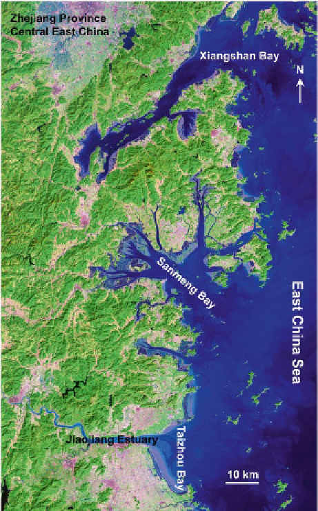
Fig. 9.6
Satellite photo of central-east Zhejiang coast showing
the development of different tidal flats in the estuaries or embay-
ments: (
a
) Xiangshan Bay, partly filled type with narrow bay-
mouth and “¬” shape; (
b
) Sanmeng Bay, partly filled type with
relatively narrow baymouth and gourd shape; (
c
) Jiaojiang
Estuary-Taizhou Bay, highly filled coastal plain type with a wide
baymouth and straight coastline ĄThey are typical representa-
tive for the three major estuarine tidal flats in the classification
lists of the Fig. 9.1
monsoon climate (Harris et al.
1993
; Li et al.
2000
;
Yang et al.
2005
; Fan et al.
2006
). During the longer
calm-weather season, shallow-water waves can be
greatly attenuated when propagating over the gentle
and broad subtidal zone, and the attenuated waves
finally die out without breaking over the intertidal flats,
especially where present with fluid mud (Wells and
Coleman
1981
; Lee et al.
1997
; Kim
2003
; Fan et al.
2006
). Open-coast tidal flats can therefore be assigned
as a tide-dominated or mix-energy tide-dominated
coastal setting on the basis of Davis and Hayes' (
1984
)
model (Fig.
9.8
). While entering the storm season,