Geology Reference
In-Depth Information
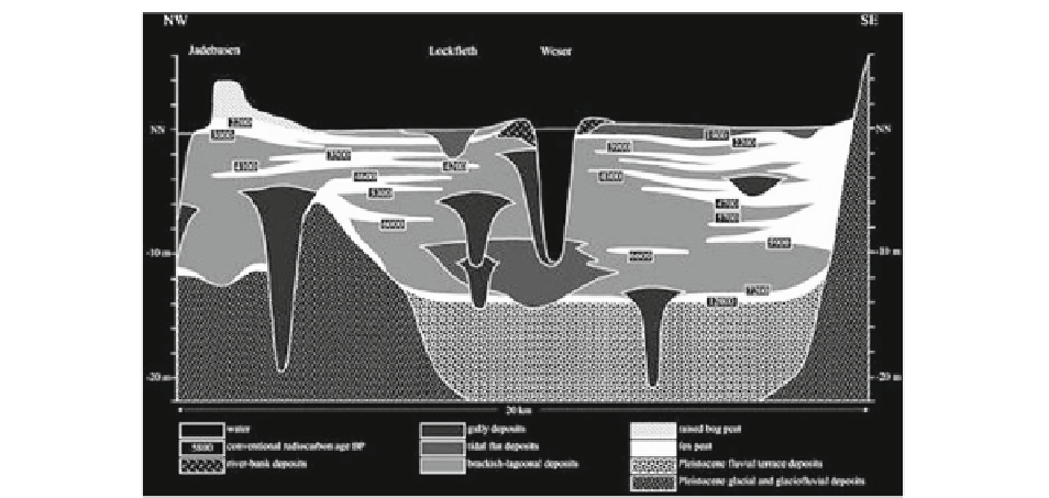
Fig. 8.23
Cross section of the Weser Estuary about 15 km upstream of Bremerhaven (From Streif
2004
)
The profi le at Kjelst (Fig.
8.22
) represents a main-
land salt marsh type which is located relatively close
to the higher Pleistocene hinterland and forms the
inland border for marine deposits. Along a transgres-
sive barrier coast, such areas on the mainland will
typically exists between smaller or larger low-laying
areas belonging to valleys of the hinterland's drain-
age system. The large valleys will also accommodate
rivers and form tide-dominated estuaries before enter-
ing the sea. In such environments, salt marsh deposits
gradually transform into freshwater marshes in an
inland direction, and, like in the example from a sec-
tion across the Weser Estuary (Fig.
8.23
, Streif
2004
) ,
become interrupted by a number of channel-fi ll
deposits (by Streif called 'gully deposits'). Apart
from this, the pattern is the same as that of the Kjelst
profi le. The sedimentation has kept phase with the
Holocene sea-level rise, and basal peat covers the
substrate followed by fi ne-grained deposits and inter-
calated peat horizons.
In Figs.
8.22
and
8.23
, no distinction has been
made between marsh and mudfl at deposits. They are
both part of the clay and brackish-lagoonal deposits
stated in the legends. It is diffi cult to distinguish
between these sediment types in the geological record,
and both will typically replace each other in turns as a
result of different degrees of inundation during the
infi ll. This is in Fig.
8.24
illustrated in a reconstruc-
tion of the Holocene evolution of the Varde Å Estuary
(for location, see Fig.
8.1
point c). The resulting rela-
tive sea-level curve is shown in Fig.
8.25
. Both fi gures
are from Pedersen et al. (
2009
) , who suggested a
method to distinguish between salt marsh clay and
tidal fl at clay in the geological record based on pres-
ence or absence of small (63-355 mm) red iron con-
cretions. When these concretions were present in the
analysed core material, there were no foraminifers
and vice versa. The concretions were therefore inter-
preted as reminiscence of gleying (mobilization and
subsequent precipitation of iron compounds), which
is typical for salt marsh deposits.
At the start of its evolution during the last part of
the Pleistocene (Fig.
8.24a
), the central area consti-
tuted a melt water valley with (presumably) a braided
river system forming the substrate with valley walls of
glacial deposits from the second last glaciation (Saale)
on both sides. At that time, the water level was far
below today's sea level. At about 8,000 years BP
(Fig.
8.24b
), the rising sea reached a level of about
−12 m DNN (Fig.
8.25
) and peat started to form in the
valley (the top of the braided river deposits is located
at about −10 m DNN). With a pause close to 3,000 BP
(a local sea-level fall), the depositional evolution con-
tinued with salt marsh forming on top of the peat until
a little before 2,000 years BP (Fig.
8.24c, d
). Hereafter,
the valley was fl ooded in its outer part (Fig.
8.24e
),
resulting in deposition of lagoonal mud as far inland as
approximately 3 km from the actual coastline. During