Geology Reference
In-Depth Information
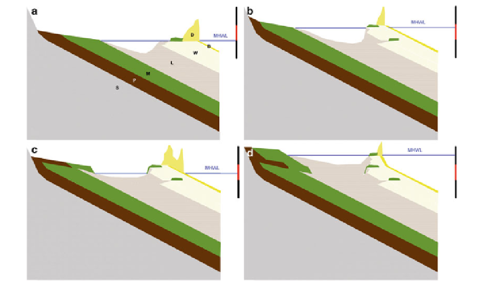
Fig. 8.21
Generalized diagram illustrating the stratigraphic rela-
tionship in a transgressive barrier system typical for the Danish
Wadden Sea. The mean high water level (MHWL) is indicated by
the position of the
horizontal blue lines
scaled on the
vertical
black
and
red
range to the
right
. The typical behaviour of this type
of barrier system is illustrated from a traditional overall model
(e.g. Galloway and Hobday
1983
) in
a
. In
b
, the water level is
raised under transgression. In
c
, the water level is lowered.
d
illus-
trates the fi nal stage after another transgressive sea-level rise. The
six facies illustrated in the diagram are:
b
beach and shore face,
d
aeolian dunes,
L
lagoon,
M
salt marsh,
W
washover,
P
peat,
S
substratum
on the backbarrier of the barrier islands/spits. Both
should be considered as part of the possible resulting
deposition of fully developed salt marsh environments
during deposition in a transgressive barrier system. In
cases of sparse sediment supply to a retreating coast-
line, the shore face front can be steep and leave noth-
ing else but lagoonal deposits behind during a
transgression. If this is not the case, however, these
backbarrier salt marshes will be preserved in the geo-
logical record as horizontal slabs of salt marsh depos-
its buried in washover sand overlaying either lagoonal
or older washover deposits as illustrated in Fig.
8.21
. It
is important here to note that even if salt marsh deposi-
tion in such an environment is small (a few tens of
centimetres), the very fact that it exists actually has an
infl uence on a several metre thick depositional units
formed by associated salt marsh creeks.
Observation of a clay bench emerging close to the
mean spring low water level on the exposed west coast
of the barrier spit Skallingen (point A in Fig.
8.1
) con-
fi rms this and suggests that these benches of salt marsh
clay form as episodic isolated depositional events,
most likely as a result of longer periods of a relatively
steady sea level. Under such conditions and if the sup-
ply of fi ne-grained sediment to the backbarrier is suf-
fi cient, salt marsh is prone to form and grow on top of
the washover sand in the lee of the foredune area. The
mentioned clay bench on the exposed coast of
Skallingen is located about 2 m below the actual
MHWL and dates back to a period of approximately
400 years centred around 1350 AD (based on three
calibrated
14
C dates of shell material: AAR-8203,
AAR-8204 and AAR-8205 from AMS 14C Dating
Laboratory, University of Aarhus). This coincides with
a cooler global temperature following the Mediaeval
warm period which culminated about 1150 AD and
was followed by the Little Ice Age with a temperature
minimum at about 1650 AD (IPCC
1990
) . In this
period - most likely - the postglacial sea-level rise was
dampened by the cooling climate conditions. From old
maps (i.e. Johannes Meyer 1654), we know that
Skallingen in the mid-seventeenth century existed in