Geology Reference
In-Depth Information
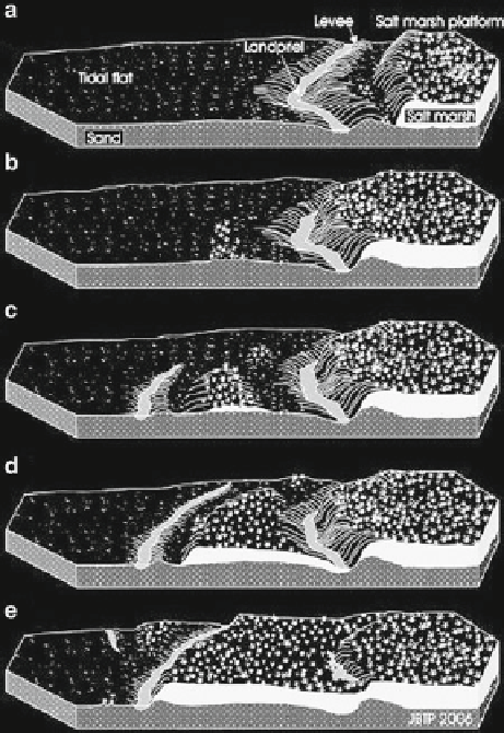
by Jakobsen (
1954
) as a natural part of the intertidal
landscape and called
landpriel
(Fig.
8.7a
). Because of
natural levee formation along the banks of the
land-
priel
, the level along its banks will eventually become
elevated and salt marsh plants will start to invade. This
is most pronounced on the marsh side facing the small
salt marsh cliff. On the tidal fl at side, the surplus mate-
rial will be reworked by waves and forms small ridges
in a broader belt of unevenly spread microtopographic
highs which eventually also form a somewhat wider
platform for salt marsh growth (Fig.
8.7b
). This creates
the necessary conditions for the formation of a new
landpriel
and a new small cliff on the exposed side of
the fi llet of newly formed salt marsh which continue to
grow (Fig.
8.7c, d
). Eventually, the old
landpriel
silts
up, and a new generation of this cyclic salt marsh
growth starts to form. This leaves the old salt marsh
cliff as a small elongated ridge in the marsh hinterland
(Fig.
8.7e
). Through time, sedimentation in salt marsh
areas has been strongly infl uenced by human activity
for agricultural purposes. The normal pattern of this
activity consists of an artifi cial draining of tidal fl at
areas by means of a system of small parallel channels
open for tidal action by means of a system of larger
channels (Fig.
8.8
). During the normal evolution of
such areas, dredged material is spread between the
channels raising the level between them. This enables
salt marsh plants to invade and further increase import
of fi ne-grained material from the adjacent tidal area.
When such an area in time has reached a level high
enough for an adequate agricultural production, it will
usually be closed by a dike. As a role, a new part of the
tidal fl at area in front of the dike will hereafter be
treated in the same way and so on. This type of land
reclamation has been used in many suitable coastal
and estuarine areas all over the world during the last
millennium. Because of the sea-level rise and as a
result of sediment compaction, this has produced
coastal zones with a landscape consisting of a succes-
sion of reclaimed areas (polders) where the fi rst, the
furthest from the sea, has the lowest level. Along with
the rising environmental awareness during the last cen-
tury, this type of land reclamation has been abandoned
in many parts of the world. In the Wadden Sea, there
are even examples of attempts to restore reclaimed
areas as shown in Fig.
8.8
that illustrates a natural
restoration project on the German Wadden Sea island
Langeoog. Here, the dike has been bridged in order to
let the normal tidal action get access to the former
reclaimed area.
Fig. 8.7
Schematic model of the cyclic growth of an exposed
salt marsh area. For scale, the length of the horizontal front is in
the order of 1 km (From Pedersen and Bartholdy
2007
)
weak spots along the salt marsh frontage, wave erosion
keeps patches free of vegetation. This creates an uneven
relief that only slowly transforms into a coherent salt
marsh surface if the salt marsh front advances and the
area becomes more sheltered against direct wave
attack. In areas with an expanding salt marsh, such
cliff areas (sometimes called microfalaise after the
French word for cliff) can be found as elongated steps
in the marsh, inland of the active cliff. In exposed salt
marsh areas, marsh expansion has been found to take
place in sequences (Jakobsen
1954
; Pedersen and
Bartholdy
2006
) as illustrated in Fig.
8.7
.
As a result of differences in hydraulic roughness
between the relatively smooth tidal fl at and the relatively
rough plant-covered salt marsh surface (Tsihrintzis and
Madiedo 2000), the transition between tidal fl ats and
salt marshes will often function as a zone where oblique
tidal or wind-induced currents are captured and guided
to run parallel to the edge. The resulting shallow channel
running parallel to the salt marsh edge was identifi ed