Geology Reference
In-Depth Information
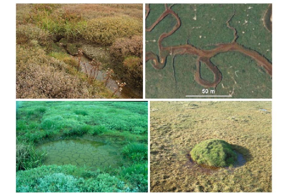
Fig. 8.5
Pictures from the backbarrier salt marsh of Skallingen
(Denmark).
Upper left
: A collapsed 'pipe' at the upper end of a
fi rst-order creek The depression is invaded by
Spartina townsendii
,
while the surrounding salt marsh is dominated by
Halimione
portulacoides
, about 30 cm high.
Upper right
: Oxbow lake as a
result of a meander neck cutoff in the central part of the salt
marsh area. Most of it is still connected to the creek system, and
will be drained at low water. Eventually, however, such cutoffs
will all be disconnected by sedimentation along the banks of the
active channels and hereafter transformed into channel salt pans.
Lower left
: Salt pan created by an exploded Second World War
mine. Note the desiccation cracks due to drying in the now inun-
dated depression.
Lower right
: Nest of the yellow meadow ant.
The depression around the nest is caused by collapsed galleries
and sand removed to build up the mound. For scale, the diameter
of the mound is approximately 1 m
unevenly spread vegetation; (2) as a result of inherit
depressions at the marsh base; (3) because of wave
attacks on weak spots; and, (4) as pointed out by Yapp
et al. (
1917
), as a result of blocking of shallow chan-
nels. Small oxbow lakes belong to this last category
(Fig.
8.5
, upper right). Salt pans can also be man-made
as the one shown in Fig.
8.5
(lower left) where a World
War II mine has created a circular depression of about
2 m in diameter. The desiccation cracks, due to dewa-
tering through drying, seen at the bottom are covered
by about 5 cm of water. When dry, this pan is covered
by small visible salt crystals giving evidence of a salt
suffering environment not suitable for plants. This
depression is located in the central part of the Skallingen
backbarrier salt marsh and experiences only restricted
wave action even during storms (Bartholdy and
Aagaard
2001
). As a result, it is not enlarging even if it
very clearly represents a 'weak spot'. It is interesting
to notice that it has kept its circular shape for over
60 years and signifi cantly lags behind its vegetated
surroundings in terms of accretion. Isolated salt pans
are by some called 'rotten spots' (Redfi eld
1972
) ,
especially when they are related to more organic-rich
salt marsh areas as those of New England, USA. In
general, most topographic variations in vegetated salt
marsh areas are dampened out as the salt marsh grows
and matures. Local exceptions for this will often be
associated with the fauna. An example of this is repre-
sented by nests of the Yellow Meadow Ant (
Lasius
Flavus
). This ant, which is common in Central Europe
and also can be found in Northern Europe, North
America, Northern Africa and Asia, excavates the ground
with galleries and feeds on the honeydew from root
aphids, which they breed here. The nest can be up to