Geology Reference
In-Depth Information
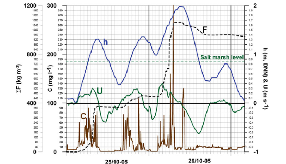
Fig. 8.3
Concentration of suspended sediment (
C
), current
velocity (
U
, +/− equals flood/ebb), water level (
h
) and cumu-
lated sediment flux (
F
, calculated as the sum of
C
·
U
·
marsh creek Store Lo at Skallingen on October 25 and 26,
2005.
C
and
U
are measured 0.5 m above the bed in the
deepest part of the channel. The cross section in which the
measurements were carried out is that of Fig.
8.2
t
based
on measurements every 5 min.) as function of time in the salt
Δ
fi brous horizons are derived from deposition of sus-
pended sediment during winter gales.
Wave activity is an important factor for mobilizing
fi ne-grained material in tidal areas. This is illustrated in
Fig.
8.3
, which shows data obtained from the same
location as that of the cross section of the salt marsh
creek shown in Fig.
8.2
(a sheltered backbarrier, repre-
sentative for such). The data set is typical for weather
types leading to import of fi ne-grained sediment to salt
marsh areas affected by wind tides. The suspended
sediment concentration and current velocity shown in
Fig.
8.3
were measured 0.5 m above the bed in the
deepest part of the creek. During the observed period, a
southwesterly gale caused a setup that fl ooded the salt
marsh. Waves in the adjacent tidal area resuspended
sediment and resulted in raised concentrations in the
water entering the creek on the fl ood tide. The highest
high water inundated the salt marsh with a water depth
of approximately 1 m. The effi ciency with which the
salt marsh traps sediment is emphasized by the almost
clean water running back during ebb, and the resulting
fl ood-directed fl ux of suspended sediment.
A number of general characteristics can be demon-
strated from this data set. First of all, the presence of
two plumes of fi ne-grained suspended sediment: (1) a
local plume, associated with sediment mobilized in the
immediate vicinity of the salt marsh creek associated
with low water; and (2) a subsequent 'regional' plume,
associated with wave suspended sediment from further
out in the adjacent tidal area associated with high water.
The fi rst represents relatively turbid water entering
the creek system at the beginning of the gale, where it
reached a maximum concentration of about 90 mg l
−1
.
During the three overmarsh tides associated with the
gale, this plume passed the measuring station with suc-
cessively smaller concentrations as the local sediment
sources 'dried out'. The second plume did build up
during the storm and reached a maximum of about
300 mg l
−1
in the descending fl ood current during the
peak of the gale. This refl ects the general concentra-
tion level in water picking up suspended matter from
muddy parts in the tidal area with a large storage
capacity. More or less all sediment associated with
these two plumes was deposited on the salt marsh
during high water slack. Only the last and largest
plume was able to cause enough deposition in the
channel region itself to form a resuspension peak of
any noticeable size at the beginning of the succeeding