Geology Reference
In-Depth Information
Delta-front Platform
Deltaplain Tidal
channel
Rivermouth Distributary
channel
Channel-mouth Bar
A. Subtidal shelf facies association
B. Migrating intertidal/subtidal
bedform facies association
C. Tidal channel facies
association
D. Incised channel facies
association
-Low energy subtidal shelf, intermittent coarse
sediment supply
Grainsize
C SFSMS
- Supratidal/intertidal channels
- Intertidal/subtidal shelf with high energy
channelised influx and intermittent surface
exposure
- Intertidal/subtidal sand rich shelf
Grainsize
C SFSMS
Grainsize
C SFSMS
12
Grainsize
C SFSMSCS
8
11
22
11
7
Sheet sands
10
20
10
6
Fluidised sands into muds
Sheet sands
Channelised sands with
bidirectional current ripples
9
18
Wave ravinement
surface
9
Intertidal
5
Sandstone
horizons
8
16
Rootlet horizon, evidence
of exposure/near surface
exposure of sediment
8
4
Channelised sands with
unidirectional climbing
current ripples
7
14
7
3
Massive
channel fill
6
12
Rhizolith clay
horizon
6
Extensive sands which fine
upwards
to silts and clays
2
5
10
5
1
4
8
4
Erosion base
0
3
6
3
Loading of sands into clay
2
4
2
Erosion surface
1
2
Erosion into
rhizolith clay
1
0
0
0
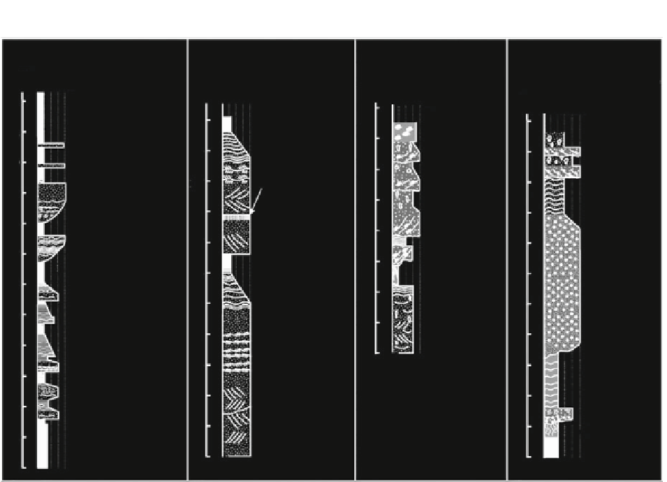
Fig. 7.6
Sketch logs of major facies associations identifi ed
from a 500-m thick Miocene-age sequence of the tide-dominated
Ganges-Brahmaputra river delta. These facies associations
comprise juxtaposed deltaic environments (see Fig.
7.3
) that
can be found within 50 km of one another in the modern
Ganges-Brahmaputra delta system (see Figs.
7.4
b and
7.5d
).
Note that neither the fl uvially dominated upper delta plain nor
the marine-dominated delta-front slope or prodelta are repre-
sented in this thick deltaic section, suggesting limited transgres-
sion/regression during this time (After Davies et al.
2003
)
on the delta-front slope are likely formed by wave-
supported hyperpycnal fl ows during storm events
(Kudrass et al.
1998
) and may be correlative with local
wave-scoured erosion surfaces on the delta-front
platform.
Where wave infl uence is high at the shoreline, sedi-
ment facies in the intertidal zone change signifi cantly
with the development of sandy beaches and longshore
bars. The Mekong and Red river deltas of Vietnam
both have beach ridges with aeolian dunes and fore-
shore with longshore bars in an intertidal zone in parts
of the delta (Thompson
1968
; Ta et al.
2005
; Tanabe
et al.
2006
; Tamura et al.
2010
). Portions of these del-
tas are also tide-dominated and characterized by man-
groves and tidal channels. Where changes in river,
wave, and tidal infl uence vary through time, reductions
in sediment supply to muddy tidal fl ats can induce ero-
sion and the downdrift formation of sand/shell-mound
along the shoreline, called 'cheniers'. Such episodic
changes locally form a series of cheniers on the prograd-
ing delta plain (Fig.
7.5a
; e.g., Changjiang, Mekong).
7.4.2
Subaqueous Delta
Seaward of the muddy subaerial delta and inner delta-
front platform, sediments typically coarsen again on
the outer delta-front platform toward the rollover point
(e.g., Changjiang, Gulf of Papua, Mekong; Hori et al.
2001
; Ta et al.
2005
). This situation is common for
deltas with a relatively shallow rollover where abrupt
shoaling across the delta-front slope exposes the