Geology Reference
In-Depth Information
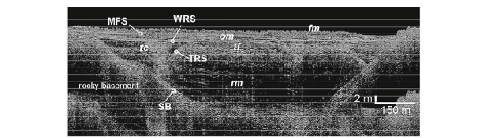
Fig. 6.2
Very high-resolution seismic profi le (boomer IKB-
Seistec, UMR CNRS M2C/University of Caen) shot in the outer
tide-dominated rocky coast estuary of the Vilaine (Southern
Brittany, NW France). VHR seismic data provide detailed
images of incised-valley infi ll and, combined with core data and
radiocarbon dating, have contributed to signifi cantly improve
our knowledge of estuary stratigraphy.
SB
sequence boundary,
TRS
tidal ravinement surface,
WRS
wave ravinement surface,
MFS
maximum fl ooding surface,
rm
ria mud,
tc
and
tf
tidal
channels and tidal fl ats,
om
offshore muds,
fm
fl uvial muds
(Modifi ed after Menier et al.
2010
)
radiocarbon data, increasing signifi cantly our knowl-
edge of coastal stratigraphy. The seismic profi le shown
in Fig.
6.2
illustrates how very high-resolution seismic
data allow detailed imaging of the different deposi-
tional units and surfaces that partly characterize an
estuary infi ll. However, such accurate very high-
resolution seismic data are not yet available in many tide-
dominated estuaries, not to mention that in many cases,
biogenic gas that is produced in the infi lling sediment,
frequently composed of organic-rich deposits, prevents
the acquisition of good-quality seismic images. At last,
seismic data should be ground-truthed by core data,
and collecting good-quality long cores in soft sedi-
ments in subtidal zones still remains a challenging
technical objective.
14,000 years ago, followed by a minimum (−10-15 m/
present-day zero) about 7,500 years ago, before rising
to the present-day level. As a result, the Cobequid
Bay-Salmon River estuary comprises a compound
infi ll composed of a Pleistocene unit and a Holocene
unit (Fig.
6.4
).
The Pleistocene unit is principally composed of
glacio-fl uvial to glacio-marine deposits that are not
described here. The Holocene succession is divided
into two stages that coincide with the early to mid-
Holocene lowstand to early transgression (9,000-
5,000 years BP) and the subsequent mid- to late
Holocene transgression (5,000 years BP - present).
Based on numerical modeling and the geometrical
aspects of sedimentary bodies, the succession that fi lls
the Cobequid Bay-Salmon River valley is interpreted
to have accumulated in a micro- to mesotidal wave-
dominated estuary during the lowstand - early trans-
gression stage, comprising spit barrier, tidal inlet,
washover, fl ood delta, central basin deposits and bay-
head delta deposits. A drastic increase in tidal range
occurred during the second stage, probably in relation
with the destruction of the barrier at the wave-
dominated estuary mouth (Shaw et al.
2010
) . The
Cobequid Bay-Salmon River estuary then evolved as
a tide-dominated estuary. The associated infi lling is
marked at the base by an extensive erosional surface
underlying tidal facies made up of axial sands and
fringing mudfl ats and marshes. Tidal sand is the
thickest above the present-day longitudinal bars and
contains superimposed sets of gently inclined stratifi -
cation. This tide-dominated estuary unit, overlying the
6.3.2
Modern Estuaries with Low
River Sediment Supply
6.3.2.1 Cobequid Bay-Salmon River
Estuary, Bay of Fundy
The infi ll of the Cobequid Bay-Salmon River estuary
was investigated by the end of the 1980s on the basis
of high-resolution seismic data (sparker source) and
cores. Tidal range is up to 16 m, and sediment supply
is mainly derived from a marine source, at least since
the mid- to late Holocene. As in most other modern
estuaries around the world, sediment infi ll is related
to the last post-glacial sea-level evolution. Due to
the glacio-isostatic rebound, the post-glacial sea
level reached a maximum (+15 m/present-day zero)