Geology Reference
In-Depth Information
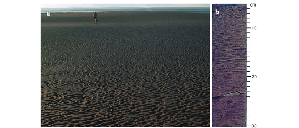
Fig. 5.15
(
a
) Surface of upper-flow-regime sand flat at low
tide, covered with current ripples. Beneath the surface, the pre-
dominant structure is parallel lamination. (
b
) Epoxy peel of a
core from the upper-flow-regime sand flats, showing abundant
parallel lamination, with scattered sets of current ripples,
here showing bipolar paleocurrent directions. Although the
suspended-sediment concentration is high in this area, there are
few mud drapes (one is present at 23-24 cm depth) because of
subsequent erosion (Both images from the Cobequid Bay—
Salmon River estuary)
5.4.2.2
Inner Estuary: Tidal-Fluvial Transition
This zone (zone 3 of Dalrymple et al.
1991
) stretches
from the limit of tidal action to the location where sig-
nificant widening occurs, allowing the development of
several ebb and flood channels. Note that this is defined
more broadly than the 'tidal-fluvial transition' subdivi-
sion in Dalrymple and Choi (
2007
), and encompasses
the entire 'straight'—meandering—'straight' channel
pattern discussed above (Figs.
5.1
and
5.8
). In this
zone as distinguished here, there is a single main ebb
channel that is only locally flanked by flood barbs on
the seaward side of the point bars that occur along the
channel (Fig.
5.10c
). The nature of the deposits in this
zone, which is transitional between purely fluvial
deposition beyond the tidal limit and almost purely
tidal sedimentation at the seaward end, is not known in
detail and more work is needed. Based largely on theo-
retical considerations, supplemented by the limited
available information (Billeaud et al.
2007
; Van den
Berg et al.
2007
), Dalrymple and Choi (
2007
) have
speculated on the deposit characteristics. In at least
some systems with a large tidal range, upper-flow-
regime conditions prevail in the outer, tide-dominated
part of the transition, occupying the thalweg and/or
lower part of the point bars (Hamilton
1979
; Lambiase
1980
; Dalrymple et al.
1990
; Billeaud et al.
2007
), pro-
ducing deposits that are similar to those in the braided
sand-flat zone that lies immediately seaward (i.e.
by subsequent currents. They are most prominent in
situations where one of the channels that occur in this
area gets cut off and fills with heterolithic strata that
might include fluid-mud layers, and in the transition to
the flanking mudflats. Comminuted organic detritus,
which is commonly referred to as
coffee grounds
or
tea
leaves
because of its granular appearance, can also
form drapes.
In estuaries that lie immediately down-drift (with
respect to mud dispersal) of a major river, the erosional
area at the mouth is replaced by muddy deposits (e.g.,
the Hangzhou Bay-Qiantangjiang estuary, Zhang and
Li
1996
; Li et al.
2006
). Descriptions of this facies lack
detail, but indicate the presence of sandy laminae,
1-2 mm thick, interbedded with mud layers several
centimeters thick. It is likely that this stratification
reflects the action of storm waves (cf. Fig.
5.2
). Based
on observations in tide-dominated deltas (Kuehl et al.
1996
; Dalrymple et al.
2003
), it is possible that these
muddy layers could be rapidly deposited from high-
density, wave-generated suspensions, rather than hav-
ing accumulated by slow settling. Vertical burrows and
shell debris are also reported from this facies. Terrestrial
organic material is also present and probably increases
in abundance in the landward transition into fine sand
and/or silty sand. The nature of the structures in this
transition zone is not reported; more detailed studies
are needed.