Geology Reference
In-Depth Information
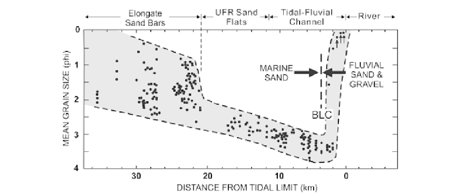
Fig. 5.12
Distribution of mean grain size (each
dot
is an
individual sample mean) in the axial channels as a function of
position within the Cobequid Bay—Salmon River estuary, Bay
of Fundy (Fig.
5.1a
). Note that the sediment is coarsest at
the mouth and head of the estuary, and finest at the bedload
convergence (cf. Fig.
5.10
). The abrupt decrease in the size of
the coarsest sediment at 21 km is coincident with the inner end
of the complex of elongate tidal sand bars, and, more specifi-
cally, with the termination of the large flood barb that lies to the
north of the main bar chain. See text for further discussion
has been documented in greatest detail in the Cobequid
Bay—Salmon River estuary, but is also evident in the
Bristol Channel—Severn River estuary (Hamilton
1979
; Harris and Collins
1985
).
The above pattern of grain-size variation is conspic-
uously absent in a small number of tide-dominated
estuaries, the best documented example being the
Hangzhou Bay-Qiantangjiang estuary, China (Zhang
and Li
1996
; Li et al.
2006
). In this system, the outer
estuary is muddy rather than sandy, and sediment
becomes sandier into the estuary. The cause of this
anomalous trend lies in the fact that the local seafloor
beyond the mouth of the estuary is mantled with mud
that escapes from a nearby, updrift river, namely the
Changjiang River to the north, and is carried into the
Qiantangjiang estuary because of the flood-tide domi-
nance of the outer estuary (Xie et al.
2009
). The land-
ward coarsening trend is caused by the inward increase
in tidal-current speeds, coupled with the addition of
coarse sediment by the river at the head of the estuary.
The Charente estuary, on the western coast of France,
shows some similarity to this trend, because of the
input of mud from the Gironde estuary to the south
(Chaumillon and Weber
2006
). It has been discovered
in recent years that the suspended sediment issuing
from major rivers tends to be advected in one direction
along the coast, as a result of the Coriolis affect, oce-
anic circulation and/or coastal winds. Thus, down-drift
estuaries are likely to have muddy rather than sandy
mouths, whereas estuaries up-drift of major rivers are
more prone to being sandy in their outer part.
5.4.2
Facies Characteristics
5.4.2.1
Outer Estuary: Axial Deposits
In the majority of tide-dominated estuaries, three facies
zones can be distinguished in the outer part of the
estuary: an erosional lag seaward of the area of sand
accumulation, elongate tidal sand bars, and an area of
upper-flow-regime sedimentation.
The sea floor beyond the tip of the elongate tidal sand
bars is generally erosional and is the marine source area
for the estuary. Stratigraphically, it represents a tidal
ravinement surface. Older sediments can be exposed
here, and the surface is mantled by a lag of coarser
sediment if such coarse sediment is available; erosional
scours, sand ribbons, and isolated dunes or dune fields
can occur (Harris and Collins
1985
; see also discussion
of
bedload-parting zones
in Chap. 13).
The elongate tidal bars at the mouth of the estuary
are typically composed of medium to coarse sand
(Fig.
5.12
); consequently, they are generally covered
by various types of subaqueous dunes (Figs.
5.10a
,
5.13
a and
5.14a
; cf. Ashley
1990
). The morphology
and dynamics of these bedforms have been reviewed