Geology Reference
In-Depth Information
2. A narrower inner estuary that is characterized by a
single main ebb channel with, or without, flanking
flood channels (zone 3 of Dalrymple et al.
1990
) that
are bordered by muddy tidal flats and salt marshes.
5.3.2
Outer Estuary
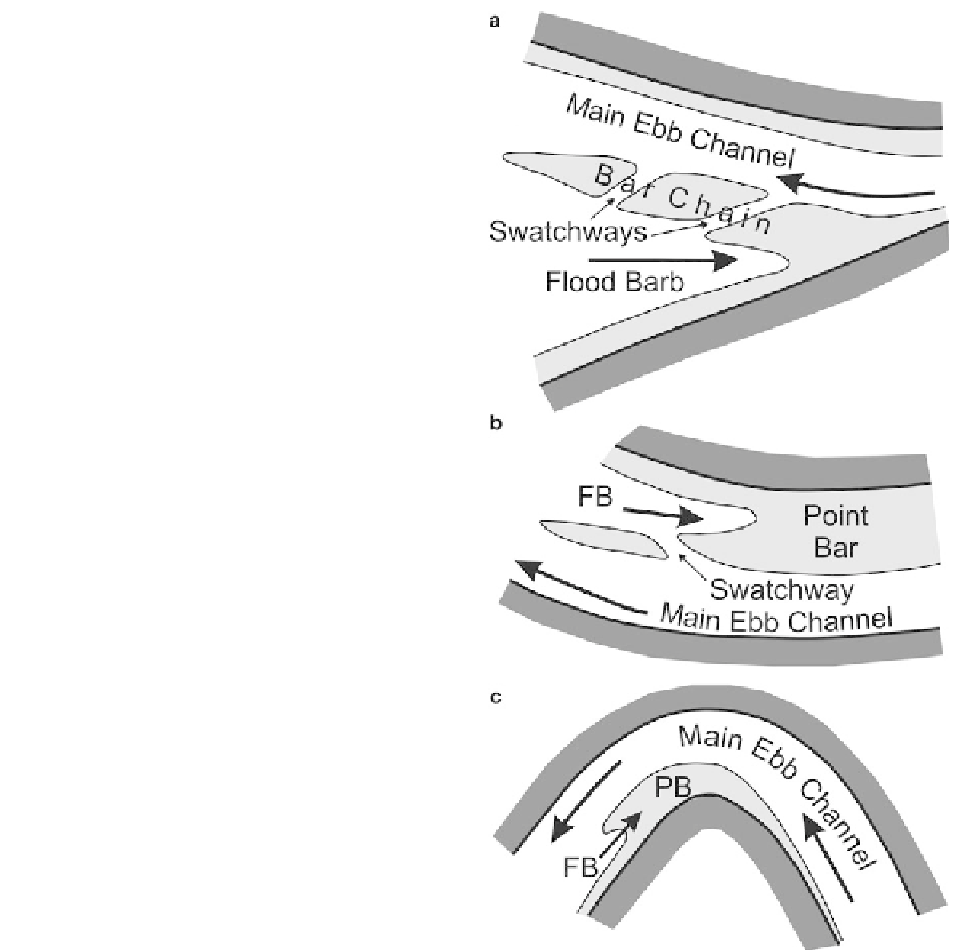
In the broad, outer part of tide-dominated estuaries, the
ebb- and flood-dominant channels form a
mutually
evasive
system of channels that are separated by elon-
gate tidal bars (Figs.
5.1
and
5.3
). The morphology and
size of these elongate tidal bars has been reviewed by
Dalrymple and Rhodes (
1995
). These bars and chan-
nels form seemingly complex patterns (Fig.
5.1a
), the
morphology of which follows a few general rules. In
general, the bars lie approximately parallel to the main
ebb and flood currents, but with a deviation of approxi-
mately 20° from the peak currents. The largest bars
commonly occupy one or both flanks of the main ebb
channel, with the opposite side of these large bars
being bordered by the largest of the headward-
terminating flood channels (Fig.
5.9a
). These large
bars, therefore, form a linear or very gently curved 'bar
chain' (Dalrymple et al.
1990
) that attaches to the side
of the estuary at its landward end. It is composed of an
en echelon
series of bars or 'bar elements' (Dalrymple
et al.
1990
) that are separated by oblique channels,
called
swatchways
(Robinson
1960
), that dissect the
bar chain and connect the ebb and flood channels. These
swatchways diverge from the ebb channel in a seaward
direction (Fig.
5.9a
) because this orientation allows the
flood currents to pass across the bar from the flood-
dominant channel into the main channel, and the ebb
currents to exit the main channel in the same way that
distributary channels accommodate part of the river's
discharge. The tidal bars can also occur as essentially
free-standing, seaward-opening U-shaped bars that
contain a flood-dominant channel between their arms.
Individual elongate bars range in length from 1 to
15 km, although bar chains can reach 40 km long. Bar
widths range from only a few hundred meters to about
4 km. The relief from the bottom of the adjacent chan-
nels to the bar crest can be as much as 20 m, but relief
as low as only a few meters is possible, especially
toward the outer end of the bar complex and particu-
larly in cases where wave action acts to flatten the
topography. The slope of the channel-bar flanks can be
as little as a fraction of a degree to nearly vertical,
Fig. 5.9
Schematic diagrams showing the morphology of chan-
nel-bar systems in (
a
) the broad outer part of an estuary, (
b
) the
relatively straight outer part of the fluvial-marine transition, and
(
c
) the more tightly meandering reach.
PB
= point bar;
FB
= flood
barb. The three parts are not to the same scale; (
a
) is several
kilometers to several tens of kilometers wide; (
b
) is a few hun-
dred to about 10 km wide; and (
c
) is less than about 2-3 km
wide. See text for more discussion
depending on the sediment that comprises the bars. If
the sediment is sandy, slopes are typically in the range
of 1-3° (cf. Fig
5.10a
); steeper slopes occur if the
elongate bars are composed of muddy material, as is
the case, for example, in the Mangyeong estuary, Korea