Geoscience Reference
In-Depth Information
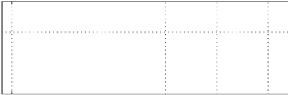
Fig. 1.2
Trend intotal icearea inthe Arcticduring June relative totheaverage from 1979 to2000
(
10
.
3
×
10
6
km
2
)
. Data from the NSIDC website, adjusted by assuming that concentration in the
satellite “pole hole” centered around the north pole (different areas depending on the satellite) is
complete (NSIDC data, Fetterer et al. 2007)
startling. In recent years, deployment of Ice Tethered Profilers (ITPs, Krischfield
et al. in press, J. Atmos. Ocean. Technol.) have provided
T
S
profiles in the upper
fewhundredmetersoftheArcticOceaninnearrealtimeallyearatseverallocations.
In2006and2007,buoyslocatedintheBeaufortGyrehaveshownremarkablyfresh
(and warm) water in the upper 100m or so compared with conditions observed in
1975duringAIDJEX.TheprofileslabeledAJXinFig.1.3aandbwereobtainedby
averagingalldatagatheredinSeptember1975,atAIDJEXstationSnowbird,which
was the northern most of the four manned stations. ITP6 was about 250km north
of the mean position of Snowbird.
4
Assuming that horizontalgradients were small
in 1975, the difference in temperature (Fig. 1.3c) implies a change of heat content
in the upper 100m of as much as 330MJm
−
2
. This is enough heat to melt (or
prevent formationof) well over a meter of sea ice if it were all somehow extracted
at the surface. The decrease in salt content is, if anything, more significant. Again,
using ice as a convenient measuring stick, the dilution implied by these profiles is
equivalenttonearly10moficemelt.Thisisclearlyamajorchangeinupper-ocean
structureinthispartoftheworld.
The Arctic Ocean resides over a mostly enclosed basin (it is often described
a Mediterranean sea) bordered by some of the broadest continental shelves found
anywhere.Thedominantanticyclonicatmosphericcirculationtendsto collectfresh
runoff and sea ice produced on the shelves inward toward the center at the sur-
face; at the same time as a layer of cold, more saline water separating the sur-
face waters from the underlying warmer water of Atlantic origin is maintained
by drainage of cold brine resulting from freezing on the shelves (Aagaard and
Coachman 1981). Thus the Arctic IOBL over much of the Arctic basin is bounded
below by a very strong density gradient (pycnocline) that effectively limits in-
teraction between the combined sea-ice/IOBL system and the underlying ocean.
In the central Beaufort Gyre this barrier appears to be strengthening, presenting
/
4
TheSeptember1975,positionsoftheAIDJEXmannedstationswereeitherinopenwaterorvery
near the ice edge inSeptember 2007.