Geology Reference
In-Depth Information
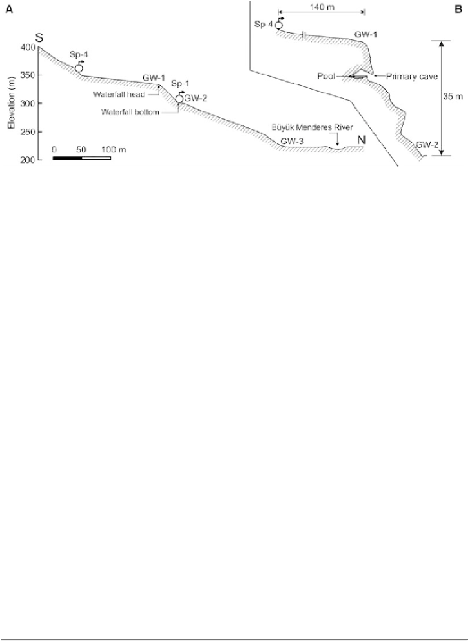
Fig. 6. A topographic cross section from the Sp-4 to the B ¨y¨ k Menderes river valley in north - south direction.
Details of the waterfall area between GW-1 and GW-2 were shown at the upper right. Sp-1 and Sp-4 are spring numbers,
GW-1, GW-2 and GW-3 are in-situ measurement points at waterfall head (¼ splash zone), waterfall bottom and
the lowermost slope, respectively.
were carried out on 11 recent and old tufa samples
from different positions. Analyses were performed
at the XRAL Laboratories in Ontario, Canada, by
ICP-AAS. The isotope analyses of
14
C activity
were made at Rudjer Boskovic Institute, in Radio-
carbon and Tritium Laboratory, Zagreb, Croatia.
The
14
C measurement was performed by liquid scin-
tillation counter (LSC), Quantulus 1220 using two
methods of sample preparation, a benzene synthesis
method (LSC-B) and a CO
2
absorption method
(LSC-D) (Horvatinˇi´ et al. 2004). Mass spec-
trometry measurements of stable isotopes content,
d
13
C and d
18
O were performed using a Finnigan
Delta XP mass spectrometer at Joanneum Research
Institute of Water Resources Management Hydro-
geology and Geophysics Stable Isotope Laboratory,
Graz, Austria. d
13
C and d
18
O in carbonates is
expressed in ‰ deviations from the international
standard PDB.
Lobe-top terrace area
At the study site, there are two distinct lobe-top ter-
races developed in different elevations. One formed
in front of Sp-2 whereas the other one formed in
front of Sp-4 (Fig. 1c). The horizontal terraces are
relatively narrow, long and restricted in areal
extent. An elevated channel was developed on the
lobe-top terrace (Fig. 3). This kind of channel pre-
viously was named as self-built channel (Bean
1971; Altunel & Hancock 1993;
¨
zkul et al.
2002), catwalk/suspended channel (Violante et al.
1994; Pedley et al. 2003; Pedley 2009) at travertine
and tufa sites. The water from Sp-4 flows along this
gently sinuous channel for about 140 m across the
subhorizontal terrace area before reaching the
active waterfall head area or spill over point
(GW-1 in Fig. 6). The channel was raised up from
a few decimetres to metre scale above the pedestal
of the lobe-top area. Lower half of the channel
length is more elevated. Local people use both ter-
races for agricultural purposes.
Depositional features of the perched
springline tufa deposits
Waterfall zone
Perched springline tufas show distinct depositional
morphologies in hilly country. The deposits are fan-
shaped in plan and wedge-like in profile (Chafetz &
Folk 1984; Pedley 1990; Ford & Pedley 1996;
Carthew et al. 2003; Pedley et al. 2003). In the
study area, the perched springline tufa site has
been mainly divided into lobe-top terrace, waterfall
(cascade) and lower slope zones.
In the study site, the waterfall area is located in the
upper part of the system. The active cascade area is
fed by the waters of Sp-4 and immediately SW of
the active side is extinct presently (Fig. 4b).
Another extinct cascade was developed in front of
Sp-2 to the NE of the tufa site (Fig. 1c). The steep
face of the waterfall is c. 35 m high and covered
Fig. 5. (Continued) base of waterfall front; (d) Cylindrical macrophyte pieces in vertical position embedded in tufa
body, lower slope, roadside section; (e) Fine- grained detrital tufas in the middle and lower right, distal slope on
the roadside section; (f ) Calcified bryophytes and coated stems; (g) Phytoherm framestone facies, immediately above
the roadside section, lower slope; (h) Coated stems and micritic tufa crust underlain by detrital tufa. Scales: Camera
cover is 13 cm, pen is 14 cm and pocket-knife is 5.5 cm.
Search WWH ::

Custom Search