Geology Reference
In-Depth Information
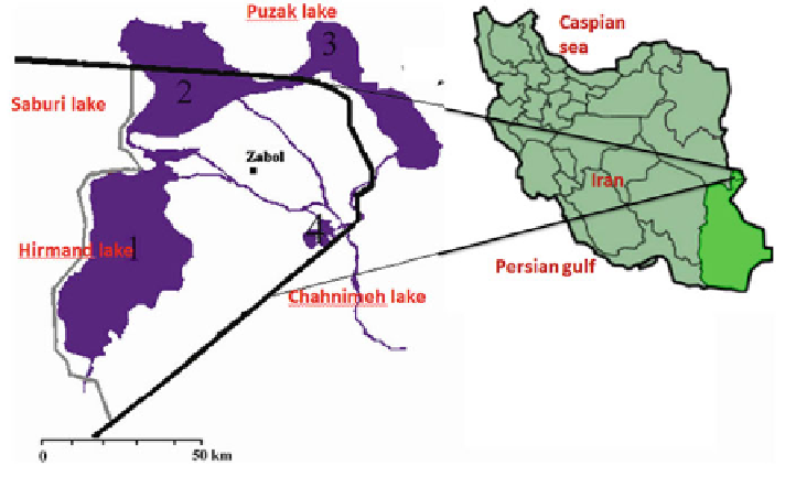
7.2.3 The Sistan Region, Iran
The Sistan region, located in the South-East of Iran, is selected as a study site for
this topic, because of its continuous evapotranspiration data availability for a def-
inite period. The location map can be found in Fig.
7.4
. The Chahnimeh reservoirs
are located in this Sistan region. The region is considered one of the severe drought
regions, generally characterized by water scarcity and low per capita water allo-
cation. Apart from this, the region is known for a notorious dust storm named
“
d-e sad-o-bist-roz), which is a highly persistent dust storm in the
summer. It blows from north to south with velocities of nearly 10 m/s. The climatic
condition in the Sistan delta is very hot and dry. During summer, the temperature
exceeds 50
120 day wind
”
(b
ā
C. Precipitation normally occurs only in autumn and winter and the
numerical value is about 60 mm/year. Strong winds are quite a distinctive feature in
the study region, and evaporation reaches a higher value of about 3,200 mm/year.
One can see in the
°
figure that the Hirmand River originates from Afghanistan
and bifurcates into two branches when it reaches the Iranian border, namely Parian
and Sistan. Sistan is the main stream of the Hirmand River, which
ows through the
Sistan plain and discharges into the natural swamp of Hamun-e-Hirmand, which
also supplies water to Sistan va, the Baluchistan province. The Chahnimeh reservoir
was constructed in the region with a view to having better control over the dis-
tribution of the water reaching the Sistan irrigated plain. At present there are three
operational reservoirs, mainly for water supply, and a fourth reservoir is under
construction.